1930s Maps of Thompson Falls, Montana
Explore 2 historic maps of Thompson Falls from the 1930s. These maps offer a rare glimpse into what life looked like during the 1930s — showing old roads, neighborhoods, homes, and landmarks that have changed or disappeared over time.
Whether you're researching your family's past, planning a metal detecting trip, or studying how Thompson Falls's landscape evolved across the 1930s, these high-resolution maps are a powerful tool for exploring the history of this region.
- Focus on a specific era: All maps on this page are from the 1930s, giving you a focused view of this time period.
- See what’s changed: Compare century-old streets, trails, and buildings to today's modern landscape using overlays and satellite layers.
- Research with precision: Use these maps for genealogy, historical research, land use analysis, or educational projects.
- View, download, or print: Maps are fully viewable online in high resolution, and can be downloaded or printed for your own records.
Start exploring Thompson Falls's history through authentic maps from the 1930s. This is your window into the past.
Thompson Falls, MT maps
(2)- 1937 Map of Thompson Falls
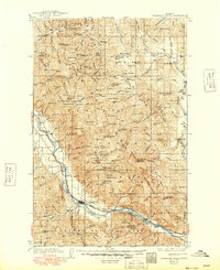
 1937 Thompson Falls1937 Print · USGSThe Clark Fork river valley and the high Cabinet Mountains are documented here in the mid-1930s. Genealogists and researchers can trace the early railroad communities of Thompson Falls and Belknap or locate the Silver Butte Fisher Sch and Bend Ranger Sta.2 unique versions available
 - 1937 Map of Thompson Falls, 1949 Print
 1937 Thompson Falls1949 Print · USGSThe Clark Fork valley in the 1930s was a vital corridor defined by the Northern Pacific Line and riverside settlements. Researchers can trace early infrastructure and mountain life through the locations of the Silver Butte Fisher Sch, the Bend Ranger Sta, and the ferry at Eddy.
End of results
Showing maps 1-2 of 2
Frequently asked questions
- What are the different types of historical maps available for Thompson Falls?
- What is the oldest map of Thompson Falls?
- Where can I purchase historical maps of Thompson Falls for my home or office?
- Where can I download high-res historical maps of Thompson Falls?
- Are there historical topographic maps available for Thompson Falls?
- Is there historical aerial imagery available for Thompson Falls?
- Where are historical maps of Thompson Falls sourced from?