1980s Maps of Westby, Montana
Explore 2 historic maps of Westby from the 1980s. These maps offer a rare glimpse into what life looked like during the 1980s — showing old roads, neighborhoods, homes, and landmarks that have changed or disappeared over time.
Whether you're researching your family's past, planning a metal detecting trip, or studying how Westby's landscape evolved across the 1980s, these high-resolution maps are a powerful tool for exploring the history of this region.
- Focus on a specific era: All maps on this page are from the 1980s, giving you a focused view of this time period.
- See what’s changed: Compare century-old streets, trails, and buildings to today's modern landscape using overlays and satellite layers.
- Research with precision: Use these maps for genealogy, historical research, land use analysis, or educational projects.
- View, download, or print: Maps are fully viewable online in high resolution, and can be downloaded or printed for your own records.
Start exploring Westby's history through authentic maps from the 1980s. This is your window into the past.
Westby, MT maps
(2)- 1983 Map of Westby South, 1984 Print
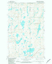
 1983 Westby South1984 Print · USGSThe Montana-North Dakota borderlands in the early eighties reveal a landscape shaped by rail travel and energy exploration. Researchers can locate family sites near the Daneville Cem, trace the Soo Line into Westby, or identify numerous oil wells and the central Goose Lake.
 - 1983 Map of Westby North, 1984 Print
 1983 Westby North1984 Print · USGSSheridan County and the international border come to life in the early eighties as energy extraction meets traditional prairie life. Trace the rail-and-well economy through the Soo Line, the Flat Lake Oil Field, and the border town of Westby.2 unique versions available
End of results
Showing maps 1-2 of 2
Frequently asked questions
- What are the different types of historical maps available for Westby?
- What is the oldest map of Westby?
- Where can I purchase historical maps of Westby for my home or office?
- Where can I download high-res historical maps of Westby?
- Are there historical topographic maps available for Westby?
- Is there historical aerial imagery available for Westby?
- Where are historical maps of Westby sourced from?