1980s Maps of Choteau, Montana
Explore 2 historic maps of Choteau from the 1980s. These maps offer a rare glimpse into what life looked like during the 1980s — showing old roads, neighborhoods, homes, and landmarks that have changed or disappeared over time.
Whether you're researching your family's past, planning a metal detecting trip, or studying how Choteau's landscape evolved across the 1980s, these high-resolution maps are a powerful tool for exploring the history of this region.
- Focus on a specific era: All maps on this page are from the 1980s, giving you a focused view of this time period.
- See what’s changed: Compare century-old streets, trails, and buildings to today's modern landscape using overlays and satellite layers.
- Research with precision: Use these maps for genealogy, historical research, land use analysis, or educational projects.
- View, download, or print: Maps are fully viewable online in high resolution, and can be downloaded or printed for your own records.
Start exploring Choteau's history through authentic maps from the 1980s. This is your window into the past.
Choteau, MT maps
(2)- 1984 Map of Choteau
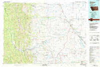 1984 Choteau1984 Print · USGSThe Teton River country comes to life in this mid-eighties record of the Montana plains and mountains. Trace the footprints of early ranching and farming settlements like Farmington and Eastham Junction, or explore the unique Hutterite settlements at Miller Colony and New Rockport Colony.
 - 1987 Map of Choteau
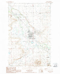 1987 Choteau1987 Print · USGSThe Teton County seat comes into focus during the late eighties, showing the town and its vital irrigation network. Genealogists can locate the town Cem and Choteau street grid, while researchers can trace the limits of the Teton-Spring Creek Bird Reserve.
End of results
Showing maps 1-2 of 2
Top cities near Choteau
Frequently asked questions
- What are the different types of historical maps available for Choteau?
- What is the oldest map of Choteau?
- Where can I purchase historical maps of Choteau for my home or office?
- Where can I download high-res historical maps of Choteau?
- Are there historical topographic maps available for Choteau?
- Is there historical aerial imagery available for Choteau?
- Where are historical maps of Choteau sourced from?