1980s Maps of Thoeny, Montana
Explore 2 historic maps of Thoeny from the 1980s. These maps offer a rare glimpse into what life looked like during the 1980s — showing old roads, neighborhoods, homes, and landmarks that have changed or disappeared over time.
Whether you're researching your family's past, planning a metal detecting trip, or studying how Thoeny's landscape evolved across the 1980s, these high-resolution maps are a powerful tool for exploring the history of this region.
- Focus on a specific era: All maps on this page are from the 1980s, giving you a focused view of this time period.
- See what’s changed: Compare century-old streets, trails, and buildings to today's modern landscape using overlays and satellite layers.
- Research with precision: Use these maps for genealogy, historical research, land use analysis, or educational projects.
- View, download, or print: Maps are fully viewable online in high resolution, and can be downloaded or printed for your own records.
Start exploring Thoeny's history through authentic maps from the 1980s. This is your window into the past.
Thoeny, MT maps
(2)- 1984 Map of Opheim
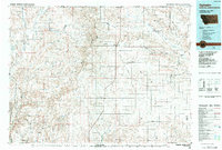 1984 Opheim1984 Print · USGSNortheastern Montana’s borderlands are captured here in the mid-1980s, where the high plains meet the international boundary. Researchers can trace the BURLINGTON NORTHERN rail line through small grain-belt settlements like Glentana and Richland or locate the OPHEIM AIR FORCE STATION and several local coal operations like the Sioux City Mine.
 - 1984 Map of Thoeny
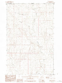 1984 Thoeny1984 Print · USGSThe Montana-Saskatchewan borderland in the mid-1980s reveals a quiet landscape of prairie coulees and remote ranching outposts. Trace the drainage patterns of Mc Eachern Creek and Rock Creek near the small settlement of Thoeny and the northern Bluff.
End of results
Showing maps 1-2 of 2
Frequently asked questions
- What are the different types of historical maps available for Thoeny?
- What is the oldest map of Thoeny?
- Where can I purchase historical maps of Thoeny for my home or office?
- Where can I download high-res historical maps of Thoeny?
- Are there historical topographic maps available for Thoeny?
- Is there historical aerial imagery available for Thoeny?
- Where are historical maps of Thoeny sourced from?