1980s Maps of Judith Gap, Montana
Explore 2 historic maps of Judith Gap from the 1980s. These maps offer a rare glimpse into what life looked like during the 1980s — showing old roads, neighborhoods, homes, and landmarks that have changed or disappeared over time.
Whether you're researching your family's past, planning a metal detecting trip, or studying how Judith Gap's landscape evolved across the 1980s, these high-resolution maps are a powerful tool for exploring the history of this region.
- Focus on a specific era: All maps on this page are from the 1980s, giving you a focused view of this time period.
- See what’s changed: Compare century-old streets, trails, and buildings to today's modern landscape using overlays and satellite layers.
- Research with precision: Use these maps for genealogy, historical research, land use analysis, or educational projects.
- View, download, or print: Maps are fully viewable online in high resolution, and can be downloaded or printed for your own records.
Start exploring Judith Gap's history through authentic maps from the 1980s. This is your window into the past.
Judith Gap, MT maps
(2)- 1986 Map of Judith Gap
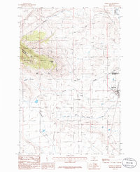 1986 Judith Gap1986 Print · USGSThe high plains of central Montana meet the mountains in the mid-1980s at this strategic three-county junction. Researchers can trace the layout of Judith Gap, the nearby Cem, and landmarks like Oka Butte and the Lewis and Clark National Forest.
 - 1986 Map of Elephant Rocks
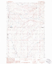 1986 Elephant Rocks1986 Print · USGSCentral Montana ranching country comes into focus in the mid-1980s, documenting the corridor near the Judith Basin and Wheatland county lines. Genealogists can trace family holdings near Judith Gap, Garneill, and the landmark Elephant Rocks.
End of results
Showing maps 1-2 of 2
Top cities near Judith Gap
Frequently asked questions
- What are the different types of historical maps available for Judith Gap?
- What is the oldest map of Judith Gap?
- Where can I purchase historical maps of Judith Gap for my home or office?
- Where can I download high-res historical maps of Judith Gap?
- Are there historical topographic maps available for Judith Gap?
- Is there historical aerial imagery available for Judith Gap?
- Where are historical maps of Judith Gap sourced from?