1970s Maps of Broadview, Montana
Explore 2 historic maps of Broadview from the 1970s. These maps offer a rare glimpse into what life looked like during the 1970s — showing old roads, neighborhoods, homes, and landmarks that have changed or disappeared over time.
Whether you're researching your family's past, planning a metal detecting trip, or studying how Broadview's landscape evolved across the 1970s, these high-resolution maps are a powerful tool for exploring the history of this region.
- Focus on a specific era: All maps on this page are from the 1970s, giving you a focused view of this time period.
- See what’s changed: Compare century-old streets, trails, and buildings to today's modern landscape using overlays and satellite layers.
- Research with precision: Use these maps for genealogy, historical research, land use analysis, or educational projects.
- View, download, or print: Maps are fully viewable online in high resolution, and can be downloaded or printed for your own records.
Start exploring Broadview's history through authentic maps from the 1970s. This is your window into the past.
Broadview, MT maps
(2)- 1979 Map of Roundup
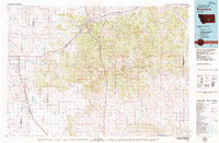 1979 Roundup1979 Print · USGSCentral Montana at the close of the 1970s reveals a landscape defined by coal mining and major rail lines. Researchers can trace the industrial legacy of Roundup and Klein or locate landmarks like the Western Mine and Steamboat Butte.
 - 1979 Map of Broadview East, 1980 Print
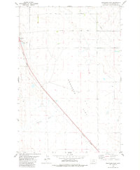 1979 Broadview East1980 Print · USGSYellowstone County's open plains are captured here in the late seventies as the region maintained its agricultural and industrial character. Researchers can trace the Burlington Northern rail line as it passes Broadview and crosses the wide Comanche Flat.
End of results
Showing maps 1-2 of 2
Top cities near Broadview
Frequently asked questions
- What are the different types of historical maps available for Broadview?
- What is the oldest map of Broadview?
- Where can I purchase historical maps of Broadview for my home or office?
- Where can I download high-res historical maps of Broadview?
- Are there historical topographic maps available for Broadview?
- Is there historical aerial imagery available for Broadview?
- Where are historical maps of Broadview sourced from?