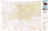
1979 Map of Roundup
USGS Topo · Published 1979About this map
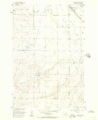
The Musselshell River carves through a landscape of coal mining and cattle country in this 1979 survey of central Montana. The town of Roundup serves as a regional hub, surrounded by smaller coal-related settlements such as Klein, Gibbtown, and Farreltown. The presence of the Western Mine and Niva Mine highlights the industrial character of the area, while the Chicago Milwaukee ST Paul And Pacific and Burlington Northern railroads underscore the importance of transit in moving resources to market. To the south, the terrain descends toward the Yellowstone River, passing through the wide open reaches of Comanche Flat and Hay Basin. Landmarks like Naderman Buttes and Steamboat Butte provide distinctive orientation points across the Musselshell and Yellowstone watersheds. This survey documents the intersection of heavy rail, resource extraction, and the enduring agricultural layout of the Big Sky country.
Find a feature on this map
65 named features on this map. Tap any name to fly to it.
Don’t see what you’re looking for? This feature index may not catch every label — zoom into the map to look around manually.
Map Details
Editions of this 1979 Roundup Map
This is the sole edition of this map. No revisions or reprints were ever made.
Other maps of this area

1889 · Big Snowy Mountain
USGS Topo · 1:250,000

1892 · Stillwater
USGS Topo · 1:125,000

1893 · Big Snowy Mountain
USGS Topo · 1:250,000

1893 · Huntley
USGS Topo · 1:125,000

1894 · Fort Custer
USGS Topo · 1:125,000

1954 · Billings
USGS Topo · 1:250,000

1954 · Hardin
USGS Topo · 1:250,000

1954 · Forsyth
USGS Topo · 1:250,000

1954 · Roundup
USGS Topo · 1:250,000
1956 · Comanche
USGS Topo · 1:24,000