1890s Maps of Arthur County, Nebraska
Explore 2 historic maps of Arthur County from the 1890s. These maps offer a rare glimpse into what life looked like during the 1890s — showing old roads, neighborhoods, homes, and landmarks that have changed or disappeared over time.
Whether you're researching your family's past, planning a metal detecting trip, or studying how Arthur County's landscape evolved across the 1890s, these high-resolution maps are a powerful tool for exploring the history of this region.
- Focus on a specific era: All maps on this page are from the 1890s, giving you a focused view of this time period.
- See what’s changed: Compare century-old streets, trails, and buildings to today's modern landscape using overlays and satellite layers.
- Research with precision: Use these maps for genealogy, historical research, land use analysis, or educational projects.
- View, download, or print: Maps are fully viewable online in high resolution, and can be downloaded or printed for your own records.
Start exploring Arthur County's history through authentic maps from the 1890s. This is your window into the past.
Arthur County, NE maps
(2)- 1897 Map of Ogallala, 1957 Print
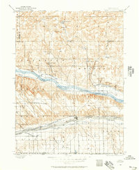 1897 Ogallala1957 Print · USGSWestern Nebraska at the end of the nineteenth century was a corridor of pioneer transit and emerging ranch life. Genealogists and historians can trace the Old California Trail, the Union Pacific rail line, and numerous family homesteads like Kingsley's Ranch.
 - 1898 Map of Paxton, 1960 Print
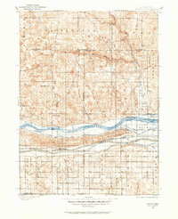 1898 Paxton1960 Print · USGSWestern Nebraska at the end of the nineteenth century reveals a landscape defined by the convergence of the Platte rivers and the arrival of the railroad. Researchers can trace early ranching sites like Duck Brand Ranch and the vital canal network including the Paxton and Hershey Canal.
End of results
Showing maps 1-2 of 2
Top cities of Arthur County
Frequently asked questions
- What are the different types of historical maps available for Arthur County?
- What is the oldest map of Arthur County?
- Where can I purchase historical maps of Arthur County for my home or office?
- Where can I download high-res historical maps of Arthur County?
- Are there historical topographic maps available for Arthur County?
- Is there historical aerial imagery available for Arthur County?
- Where are historical maps of Arthur County sourced from?