1900s (20th Century) Maps of Alliance, Nebraska
Explore 11 historic maps of Alliance from the 1900s (20th Century). These maps offer a rare glimpse into what life looked like during the 1900s — showing old roads, neighborhoods, homes, and landmarks that have changed or disappeared over time.
Whether you're researching your family's past, planning a metal detecting trip, or studying how Alliance's landscape evolved across the 1900s, these high-resolution maps are a powerful tool for exploring the history of this region.
- Focus on a specific era: All maps on this page are from the 1900s, giving you a focused view of this time period.
- See what’s changed: Compare century-old streets, trails, and buildings to today's modern landscape using overlays and satellite layers.
- Research with precision: Use these maps for genealogy, historical research, land use analysis, or educational projects.
- View, download, or print: Maps are fully viewable online in high resolution, and can be downloaded or printed for your own records.
Start exploring Alliance's history through authentic maps from the 1900s. This is your window into the past.
Alliance, NE maps
(11)- 1946 Map of Berea Creek East, 1977 Print
 1946 Berea Creek East1977 Print · USGSBox Butte County in the mid-forties reveals a classic Nebraska Panhandle ranching landscape marked by a network of rural schoolhouses. Genealogists can locate family landmarks like Plainview Cem or trace the early paths of Hemingford Creek and School No 78.
 - 1947 Map of Alliance, 1967 Print
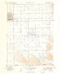
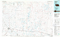
 1947 Alliance1967 Print · USGSAlliance emerges as a bustling panhandle hub in the late 1940s, balancing its railroad roots with new aviation infrastructure. Researchers can locate the Courthouse, trace the Chicago Burlington and Quincy rail lines, and find rural landmarks like Greenwood Cem.2 unique versions available
 - 1947 Map of Bronco Lake, 1970 Print
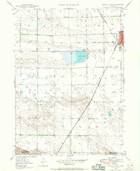 1947 Bronco Lake1970 Print · USGSThe Nebraska panhandle comes into focus in the late 1940s as the rail lines and rural school districts of Box Butte County are mapped in detail. Genealogists can trace the rural landscape through landmarks like Letan Sch, St Josephs Hospital, and the small settlement of Letan.2 unique versions available
 - 1948 Map of Berea Creek West
 1948 Berea Creek West1948 Print · USGSBox Butte County was a landscape of rail-dependent prairie settlements in the years following World War II. Genealogists and local historians can locate rural landmarks like School No 45, the tiny community of Berea, and the Yale Siding railroad stop.2 unique versions available
 - 1948 Map of Berea Creek East
 1948 Berea Creek East1948 Print · USGSBox Butte County was a landscape of remote farmsteads and rural schoolhouses just after the war. Researchers can trace the placement of local landmarks like School No 78, Plainview Cem, and the headwaters of Berea Creek.2 unique versions available
 - 1948 Map of Alliance
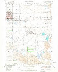
 1948 Alliance1948 Print · USGSAlliance emerges as a bustling post-war rail and aviation hub in the Nebraska panhandle during the late forties. Genealogists and researchers can trace local landmarks like Greenwood Cem, East Point Sch, and the expansive Alliance Airport.2 unique versions available
 - 1949 Map of Bronco Lake
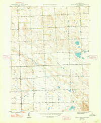
 1949 Bronco Lake1949 Print · USGSNorthwestern Nebraska ranching and rail commerce take center stage in the late 1940s as the High Plains landscape begins its post-war shift. Trace the early footprint of Alliance or locate rural landmarks like Letan Sch and the namesake Bronco Lake.2 unique versions available
 - 1955 Map of Alliance, 1966 Print
 1955 Alliance1966 Print · USGSThe Nebraska panhandle comes into sharp focus during the mid-fifties, showing a landscape defined by the Niobrara River and the expanding Sand Hills. Researchers can trace the grounds of Fort Robinson, locate Saint Marys Church, or follow the Chicago Burlington and Quincy rail line through Hemingford.3 unique versions available
 - 1957 Map of Alliance
 1957 Alliance1957 Print · USGSNorthwest Nebraska in the mid-fifties is captured here as a landscape of rail hubs, sprawling cattle ranches, and the eastern edge of the dunes. Genealogists and historians can trace rail lines through Alliance and Chadron or locate landmarks like Saint Marys Church and the Agate Spring Fossil Beds.
 - 1958 Map of Alliance
 1958 Alliance1958 Print · USGSNorthwestern Nebraska in the late fifties shows a landscape shaped by the legacy of the high plains frontier and modern agricultural expansion. Genealogists and historians can trace rail-line settlements and landmarks like Fort Robinson and the Agate Spring Fossil Beds.
 - 1985 Map of Alliance, 1986 Print
 1985 Alliance1986 Print · USGSThe High Plains of Box Butte and Sheridan counties come alive in the mid-1980s, centered on the rail hub of Alliance. Genealogists and historians can trace the Burlington Northern line through small sidings and towns like Antioch, Lakeside, and Bingham near the Niobrara River.2 unique versions available
End of results
Showing maps 1-11 of 11
Top cities near Alliance
Top neighborhoods of Alliance
- Meadows Trailer Court historical maps
- Tower Plaza Mobile Home Park historical maps
- Trailerville Court historical maps
Frequently asked questions
- What are the different types of historical maps available for Alliance?
- What is the oldest map of Alliance?
- Where can I purchase historical maps of Alliance for my home or office?
- Where can I download high-res historical maps of Alliance?
- Are there historical topographic maps available for Alliance?
- Is there historical aerial imagery available for Alliance?
- Where are historical maps of Alliance sourced from?