
1946 Map of Berea Creek East
USGS Topo · Published 1977About this map
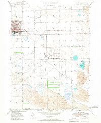
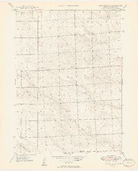
The High Plains of Box Butte County are defined by a sparse but vital network of small rural schools and cemeteries established during the early settlement of the Nebraska Panhandle. In the years following World War II, this landscape was dominated by cattle ranching and dryland farming, where the presence of a Windmill often signaled a home or water source in the arid terrain. Educational life centered on localized schoolhouses such as School No 55, School No 3, and School No 38, which served as anchors for the surrounding farm families. The hydrology of the area is shaped by the North Fork Berea Creek, Hemingford Creek, and Box Butte Cr, providing the necessary drainage for the expansive grazing lands. Social history is further preserved at Plainview Cem and Calvary Cem, marking the generations of families who established roots in this corner of the state.
Find a feature on this map
13 named features on this map. Tap any name to fly to it.
Don’t see what you’re looking for? This feature index may not catch every label — zoom into the map to look around manually.
Map Details
Editions of this 1946 Berea Creek East Map
This is the sole edition of this map. No revisions or reprints were ever made.
Other maps of this area
1947 · Alliance
USGS Topo · 1:24,000
1947 · Bronco Lake
USGS Topo · 1:24,000

1947 · Box Butte
USGS Topo · 1:24,000

1948 · Berea Creek West
USGS Topo · 1:24,000
1948 · Berea Creek East
USGS Topo · 1:24,000
1948 · Alliance
USGS Topo · 1:24,000

1948 · Antioch
USGS Topo · 1:62,500
1949 · Box Butte SW
USGS Topo · 1:24,000

1949 · Bronco Lake
USGS Topo · 1:24,000

1949 · Antioch
USGS Topo · 1:62,500