
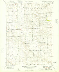
1949 Map of Box Butte SW
USGS Topo · Published 1949About this map
Running Water and Nonpareil terrain define the High Plains landscape of Box Butte County in this late 1940s survey. The area is characterized by a sparse, rural infrastructure centered on education and natural drainage. Educational landmarks like School No 30 and School No 10 are positioned along the section-line roads, serving the outlying farmstead communities of the era. The land is carved by the ephemeral flows of Box Butte Creek and Hemingford Creek, alongside the North Branch and South Branch tributaries. These watercourses were vital to the cattle ranching and dryland farming operations that dominated the Nebraska panhandle during this period of post-war agricultural stability.
Find a feature on this map
9 named features on this map. Tap any name to fly to it.
Don’t see what you’re looking for? This feature index may not catch every label — zoom into the map to look around manually.
Map Details
Editions of this 1949 Box Butte SW Map
2 editions found
Other maps of this area

1946 · Berea Creek East
USGS Topo · 1:24,000

1947 · Box Butte NE
USGS Topo · 1:24,000

1947 · Box Butte
USGS Topo · 1:24,000

1947 · Box Butte NW
USGS Topo · 1:24,000

1948 · Hemingford
USGS Topo · 1:24,000

1948 · Berea Creek West
USGS Topo · 1:24,000

1948 · Berea Creek East
USGS Topo · 1:24,000

1948 · Hemingford 4 NE
USGS Topo · 1:24,000

1948 · Box Butte Reservoir East
USGS Topo · 1:24,000

1949 · Box Butte NE
USGS Topo · 1:24,000