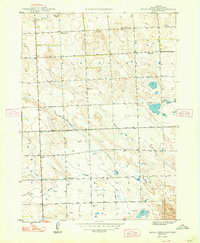
1948 Map of Berea Creek East
USGS Topo · Published 1948About this map
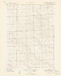
Berea Creek and its seasonal tributaries carve a subtle path across this high plains landscape of Box Butte County during the late 1940s. The map reveals a highly organized rural infrastructure, where section lines define the movement of travel and the placement of critical community hubs. Small educational centers like School No 55 and School No 3 are spaced at regular intervals, reflecting a time when local school districts served immediate farming families.
Find a feature on this map
13 named features on this map. Tap any name to fly to it.
Don’t see what you’re looking for? This feature index may not catch every label — zoom into the map to look around manually.
Map Details
Editions of this 1948 Berea Creek East Map
2 editions found

Other maps of this area

1946 · Berea Creek East
USGS Topo · 1:24,000
1947 · Alliance
USGS Topo · 1:24,000
1947 · Bronco Lake
USGS Topo · 1:24,000

1947 · Box Butte
USGS Topo · 1:24,000

1948 · Berea Creek West
USGS Topo · 1:24,000
1948 · Alliance
USGS Topo · 1:24,000

1948 · Antioch
USGS Topo · 1:62,500
1949 · Box Butte SW
USGS Topo · 1:24,000

1949 · Bronco Lake
USGS Topo · 1:24,000

1949 · Antioch
USGS Topo · 1:62,500