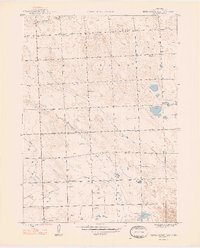
1948 Map of Berea Creek East
USGS Topo · Published 1948About this map
Box Butte County agriculture and school district boundaries define the landscape in this late 1940s survey. The area is characterized by a high density of rural schoolhouses, including School No 55, School No 3, School No 5, School No 38, and School No 78, illustrating the decentralized educational system of Nebraska's rangeland before mid-century consolidation. Water management in this semi-arid region is represented by the numerous Windmill sites that dot the sections, supporting the cattle and farming operations near the headwaters of Hemingford Creek and Berea Creek. Local heritage is anchored by two burial grounds, Plainview Cem in the north and Calvary Cem near the southern boundary. The topography shows the gradual transition of the North Fork drainage as it cuts through the local terrain, providing a look at the early infrastructure of the Nebraska panhandle.
Find a feature on this map
13 named features on this map. Tap any name to fly to it.
Don’t see what you’re looking for? This feature index may not catch every label — zoom into the map to look around manually.
Map Details
Editions of this 1948 Berea Creek East Map
2 editions found
Other maps of this area

1946 · Berea Creek East
USGS Topo · 1:24,000

1947 · Alliance
USGS Topo · 1:24,000

1947 · Bronco Lake
USGS Topo · 1:24,000

1947 · Box Butte
USGS Topo · 1:24,000

1948 · Berea Creek West
USGS Topo · 1:24,000

1948 · Berea Creek East
USGS Topo · 1:24,000

1948 · Alliance
USGS Topo · 1:24,000

1948 · Antioch
USGS Topo · 1:62,500

1949 · Box Butte SW
USGS Topo · 1:24,000
1949 · Bronco Lake
USGS Topo · 1:24,000