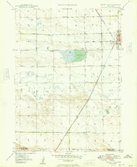
1949 Map of Bronco Lake
USGS Topo · Published 1949About this map
Alliance serves as the primary hub of this High Plains landscape, where the Chicago Burlington and Quincy railroad cuts a straight line through the tablelands of Box Butte County. The map reveals a transition from the urban grid of the city, featuring St Josephs Hospital and the Alliance Country Club, into a sprawling ranching and farming district defined by intermittent waterways and isolated rural institutions. The presence of School No 11 and School No 1 alongside the namesake Bronco Lake illustrates the scattered nature of settlement in the post-war era. Further south, the map captures the small community of Letan, supported by the Letan Sch and the railway, while the meandering path of Snake Creek provides a stark contrast to the rigid section lines that organize the surrounding territory.
Find a feature on this map
15 named features on this map. Tap any name to fly to it.
Don’t see what you’re looking for? This feature index may not catch every label — zoom into the map to look around manually.
Map Details
Editions of this 1949 Bronco Lake Map
2 editions found
Other maps of this area

1896 · Browns Creek
USGS Topo · 1:125,000

1898 · Camp Clarke
USGS Topo · 1:125,000

1899 · Browns Creek
USGS Topo · 1:125,000

1946 · Berea Creek East
USGS Topo · 1:24,000

1947 · Alliance
USGS Topo · 1:24,000

1947 · Bronco Lake
USGS Topo · 1:24,000

1948 · Hemingford 4 SE
USGS Topo · 1:24,000

1948 · Berea Creek West
USGS Topo · 1:24,000

1948 · Berea Creek East
USGS Topo · 1:24,000

1948 · Hemingford 4 NE
USGS Topo · 1:24,000