Loading...
Loading map...1948 Map of Alliance
USGS Topo · Published 1948About this map
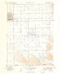
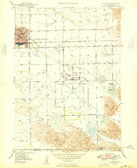
Alliance serves as the focal point of this western Nebraska landscape, appearing here as a vital regional hub shortly after World War II. The map details the urban grid including local landmarks like the Courthouse and City Hall, while the extensive Alliance Airport dominates the central plains. This facility, combined with the intersection of the Chicago and Burlington and Quincy railroads, underscores the area's importance as a transportation and logistics center.
Find a feature on this map
16 named features on this map. Tap any name to fly to it.
Don’t see what you’re looking for? This feature index may not catch every label — zoom into the map to look around manually.
Map Details
Date Portrayed1948
Date Published1948
PublisherU.S. Geological Survey
Map TypeTopographic
Scale1:24,000
Physical Dimensions22.08 x 27.39 inches
Editions of this 1948 Alliance Map
2 editions found
Historical Maps of Alliance Through Time
5 maps found


Featured Locations
Source Details
SourceU.S. Geological Survey
CopyrightPublic Domain