2020s Maps of Alliance, Nebraska
Explore 4 historic maps of Alliance from the 2020s. These maps offer a rare glimpse into what life looked like during the 2020s — showing old roads, neighborhoods, homes, and landmarks that have changed or disappeared over time.
Whether you're researching your family's past, planning a metal detecting trip, or studying how Alliance's landscape evolved across the 2020s, these high-resolution maps are a powerful tool for exploring the history of this region.
- Focus on a specific era: All maps on this page are from the 2020s, giving you a focused view of this time period.
- See what’s changed: Compare century-old streets, trails, and buildings to today's modern landscape using overlays and satellite layers.
- Research with precision: Use these maps for genealogy, historical research, land use analysis, or educational projects.
- View, download, or print: Maps are fully viewable online in high resolution, and can be downloaded or printed for your own records.
Start exploring Alliance's history through authentic maps from the 2020s. This is your window into the past.
Alliance, NE maps
(4)- 2021 Map of Berea Creek East, 2021 Print
 2021 Berea Creek East2021 Print · USGSThe rural expanse north of Alliance is captured here during the early twenty-first century, showing the intersection of deep-rooted agriculture and prairie hydrology. Researchers can locate family landmarks like Fairview Cem and trace the paths of Box Butte Creek and Hemingford Cr.
 - 2021 Map of Berea Creek West, 2021 Print
 2021 Berea Creek West2021 Print · USGSBox Butte County is shown in this recent survey, centered on the corridor between the small community of Berea and the city of Alliance. Local researchers can trace rural property boundaries and water drainage along Berea Cr and Hemingford Cr.
 - 2021 Map of Alliance East, 2021 Print
 2021 Alliance East2021 Print · USGSAlliance and the surrounding high plains of Box Butte County are shown here in the early 2020s. Genealogists and local historians can locate the Nebraska Veterans Cem at Alliance, the Box Butte County Courthouse, and the campus of Western Nebraska Community College.
 - 2021 Map of Alliance West, 2021 Print
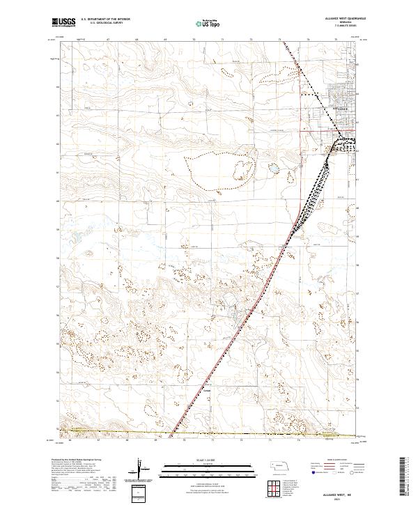 2021 Alliance West2021 Print · USGSThe western edge of the Nebraska panhandle comes into focus here in the early 2020s, where the city of Alliance meets the rural plains. Researchers can trace the path of Snake Cr or locate the settlement of Letan south of town.
End of results
Showing maps 1-4 of 4
Top cities near Alliance
Top neighborhoods of Alliance
- Meadows Trailer Court historical maps
- Tower Plaza Mobile Home Park historical maps
- Trailerville Court historical maps
Frequently asked questions
- What are the different types of historical maps available for Alliance?
- What is the oldest map of Alliance?
- Where can I purchase historical maps of Alliance for my home or office?
- Where can I download high-res historical maps of Alliance?
- Are there historical topographic maps available for Alliance?
- Is there historical aerial imagery available for Alliance?
- Where are historical maps of Alliance sourced from?