1960s Maps of Boyd County, Nebraska
Explore 8 historic maps of Boyd County from the 1960s. These maps offer a rare glimpse into what life looked like during the 1960s — showing old roads, neighborhoods, homes, and landmarks that have changed or disappeared over time.
Whether you're researching your family's past, planning a metal detecting trip, or studying how Boyd County's landscape evolved across the 1960s, these high-resolution maps are a powerful tool for exploring the history of this region.
- Focus on a specific era: All maps on this page are from the 1960s, giving you a focused view of this time period.
- See what’s changed: Compare century-old streets, trails, and buildings to today's modern landscape using overlays and satellite layers.
- Research with precision: Use these maps for genealogy, historical research, land use analysis, or educational projects.
- View, download, or print: Maps are fully viewable online in high resolution, and can be downloaded or printed for your own records.
Start exploring Boyd County's history through authentic maps from the 1960s. This is your window into the past.
Boyd County, NE maps
(8)- 1964 Map of Butte, 1965 Print
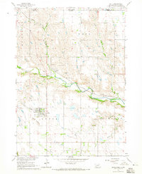 1964 Butte1965 Print · USGSThe Nebraska and South Dakota borderlands come into focus in the mid-sixties, centered on the Boyd County seat. Researchers can trace the Chicago and North Western rail line through Anoka and locate historic burial sites like Old Settlers Cem.
 - 1964 Map of Gross, 1965 Print
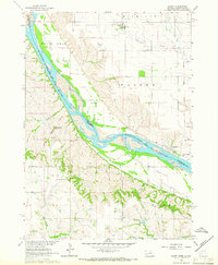
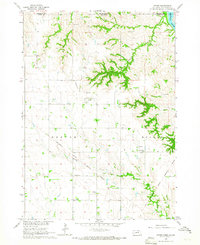 1964 Gross1965 Print · USGSBoyd County, Nebraska, and Gregory County, South Dakota, are captured in the mid-1960s as the rural landscape follows the Missouri River Basin. Genealogists and historians can trace the Old Fort Randall Military Road and locate the Rosedale Ch, Pleasant View Sch, and the settlement of Gross.
 - 1964 Map of Jamison, 1965 Print
 1964 Jamison1965 Print · USGSThe Nebraska-South Dakota borderlands come into focus in the mid-1960s, showing the intersection of the Rosebud Indian Reservation with the winding Keya Paha River. You can trace the rural communities of Jamison and Brocksburg alongside Spotted Tail Sch and Emmanuel Cem.
 - 1964 Map of Naper NW, 1966 Print
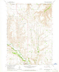
 1964 Naper NW1966 Print · USGSBoyd County, Nebraska, and the South Dakota borderlands are captured here in the mid-1960s. Researchers can locate family burial plots at the Naper Cem and German Cem or trace the winding course of the Keya Paha River through the valley.
 - 1964 Map of Lynch NE, 1966 Print
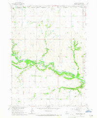
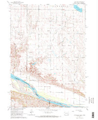 1964 Lynch NE1966 Print · USGSThe Missouri River borderlands in the mid-1960s reveal a landscape of prairie schools and treaty boundaries. Genealogists can locate family landmarks like the Native American Ch or trace old rural districts such as School No 64 and School No 80.2 unique versions available
 - 1964 Map of Spencer North, 1966 Print
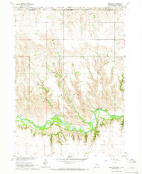
 1964 Spencer North1966 Print · USGSNorth of Spencer, the Nebraska-South Dakota border meets the old Fort Randall Military Reservation Boundary in the mid-1960s. Genealogists can trace local roots through landmarks like Messiah Ch, School No 52, and the Old Immanuel Cem.
 - 1964 Map of Marty, 1966 Print
 1964 Marty1966 Print · USGSThe Missouri River borderlands of South Dakota and Nebraska are captured here in the mid-sixties, showcasing a landscape shaped by tribal lands and military history. Genealogists can trace family footprints through the Old Yankton Indian Res Bdy, St Pauls Cem, and several rural schools like School No 83.2 unique versions available
 - 1969 Map of O'Neill
 1969 O'Neill1969 Print · USGSCentral Nebraska in the mid-fifties is defined here by the expansive Sand Hills and the winding Niobrara River. Trace the Chicago and North Western rail line through cattle towns like O'Neill and Ainsworth.
End of results
Showing maps 1-8 of 8
Top cities of Boyd County
- Spencer historical maps
- Butte historical maps
- Lynch historical maps
- Naper historical maps
- Bristow historical maps
- Anoka historical maps
See more
Frequently asked questions
- What are the different types of historical maps available for Boyd County?
- What is the oldest map of Boyd County?
- Where can I purchase historical maps of Boyd County for my home or office?
- Where can I download high-res historical maps of Boyd County?
- Are there historical topographic maps available for Boyd County?
- Is there historical aerial imagery available for Boyd County?
- Where are historical maps of Boyd County sourced from?