
1964 Map of Butte
USGS Topo · Published 1965About this map
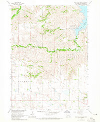
Butte serves as the primary hub in this mid-1960s study of Boyd County, Nebraska, and Gregory County, South Dakota. Situated just south of the state line, the town is a center for local services, featuring its own Fairground, Sewage Disposal, and several religious sites including SS Peter and Paul Cem and Butte Cem. The landscape is defined by the winding course of Ponca Creek, which is tracked by the Chicago and North Western railroad. To the northwest, the small settlement of Anoka sits near numerous Gravel Pits, illustrating the local extractive industry of the era.
Find a feature on this map
23 named features on this map. Tap any name to fly to it.
Don’t see what you’re looking for? This feature index may not catch every label — zoom into the map to look around manually.
Map Details
Editions of this 1964 Butte Map
This is the sole edition of this map. No revisions or reprints were ever made.
Other maps of this area

1951 · Butte NW
USGS Topo · 1:24,000

1951 · Butte SW
USGS Topo · 1:24,000

1952 · Spencer South
USGS Topo · 1:24,000

1952 · Butte SE
USGS Topo · 1:24,000

1955 · Mitchell
USGS Topo · 1:250,000

1955 · O'Neill
USGS Topo · 1:250,000

1959 · O'Neill
USGS Topo · 1:250,000

1959 · Mitchell
USGS Topo · 1:250,000

1964 · Lake Andes SW
USGS Topo · 1:24,000
1964 · South Scalp Creek
USGS Topo · 1:24,000