
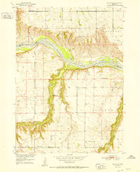
1952 Map of Butte SE
USGS Topo · Published 1952About this map
Niobrara River braids across the northern section of this 1950s survey, marking the boundary between Boyd and Holt counties. This landscape is defined by the steep bluffs and drainage patterns of Brush Creek and its tributaries as they cut through the high plains. The map reveals a rural settlement pattern centered on one-room schoolhouses spaced across the townships, including School No 12, School No 68, and the specifically noted School No 193 (Abandoned). The small community of Catalpa sits in the southwestern portion of the map, serving as a focal point for the surrounding ranches and farms. Land use in this era is further evidenced by numerous scattered windmills and a Gaging Sta along the river, illustrating the region's reliance on water management in the Nebraska sandhills fringe.
Find a feature on this map
17 named features on this map. Tap any name to fly to it.
Don’t see what you’re looking for? This feature index may not catch every label — zoom into the map to look around manually.
Map Details
Editions of this 1952 Butte SE Map
2 editions found
Other maps of this area

1951 · Butte NW
USGS Topo · 1:24,000

1951 · Butte SW
USGS Topo · 1:24,000

1952 · Spencer South
USGS Topo · 1:24,000

1954 · Meek
USGS Topo · 1:24,000

1954 · Atkinson NW
USGS Topo · 1:24,000

1954 · Atkinson NE
USGS Topo · 1:24,000

1955 · O'Neill
USGS Topo · 1:250,000

1959 · O'Neill
USGS Topo · 1:250,000

1964 · Butte
USGS Topo · 1:24,000
1964 · Spencer North
USGS Topo · 1:24,000