
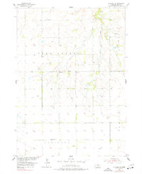
1954 Map of Atkinson NW
USGS Topo · Published 1956About this map
The rolling tablelands of Saratoga in Holt County define this mid-century landscape, where agriculture and cattle ranching shaped the rural development. Settlers established several educational centers to serve the surrounding homesteads, including Sunnyside Sch and School No 89, while the community of Beck is noted in the western reaches. The reliance on water management is evident through the numerous windmills scattered across the terrain to support livestock in the gaps between Brush Creek and Sand Creek. Near the center of the township, Celia Sch and the Celia Cem stand as markers of a localized rural cluster, providing valuable data points for those researching family history in the Atkinson and Belle precincts.
Find a feature on this map
11 named features on this map. Tap any name to fly to it.
Don’t see what you’re looking for? This feature index may not catch every label — zoom into the map to look around manually.
Map Details
Editions of this 1954 Atkinson NW Map
2 editions found
Other maps of this area

1951 · Butte SW
USGS Topo · 1:24,000

1951 · Dustin
USGS Topo · 1:24,000

1952 · Butte SE
USGS Topo · 1:24,000

1954 · Atkinson SE
USGS Topo · 1:24,000

1954 · Atkinson
USGS Topo · 1:24,000

1954 · Stuart SE
USGS Topo · 1:24,000

1954 · Atkinson NE
USGS Topo · 1:24,000

1954 · Stuart NE
USGS Topo · 1:24,000

1955 · O'Neill
USGS Topo · 1:250,000

1959 · O'Neill
USGS Topo · 1:250,000