1970s Maps of Burt County, Nebraska
Explore 8 historic maps of Burt County from the 1970s. These maps offer a rare glimpse into what life looked like during the 1970s — showing old roads, neighborhoods, homes, and landmarks that have changed or disappeared over time.
Whether you're researching your family's past, planning a metal detecting trip, or studying how Burt County's landscape evolved across the 1970s, these high-resolution maps are a powerful tool for exploring the history of this region.
- Focus on a specific era: All maps on this page are from the 1970s, giving you a focused view of this time period.
- See what’s changed: Compare century-old streets, trails, and buildings to today's modern landscape using overlays and satellite layers.
- Research with precision: Use these maps for genealogy, historical research, land use analysis, or educational projects.
- View, download, or print: Maps are fully viewable online in high resolution, and can be downloaded or printed for your own records.
Start exploring Burt County's history through authentic maps from the 1970s. This is your window into the past.
Burt County, NE maps
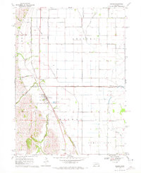
(8)- 1970 Map of Oakland SE, 1971 Print
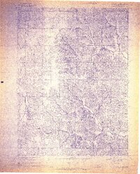 1970 Oakland SE1971 Print · USGSBurt County land and industry are captured here at the start of the 1970s, focused on the rail-side village of Craig. Genealogists and historians can trace family plots at Silver Creek Cem and follow the route of the Chicago and North Western railroad.2 unique versions available
 - 1970 Map of Little Sioux, 1972 Print
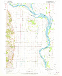
 1970 Little Sioux1972 Print · USGSThe Missouri River floodplain comes into sharp focus during the 1970s, showing a landscape shaped by both nature and heavy engineering. Genealogists and local historians can trace early residents through Little Sioux Cem and Roughcorn Cem, or follow the path of the Chicago and North Western railroad.
 - 1970 Map of Tekamah NW, 1972 Print
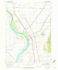
 1970 Tekamah NW1972 Print · USGSThe Missouri River floodplain comes into sharp focus during the 1970s, showing a landscape of managed drainage and small rural hubs. Researchers can trace family ties at the Riverside Ch or locate landmarks like Lake Quinnebaugh and the Huff Access County Park.
 - 1970 Map of Bertha, 1972 Print
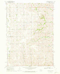
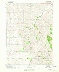 1970 Bertha1972 Print · USGSBurt County agriculture and community life are captured here in the early seventies, showing a landscape of scattered schools and prairie drainages. Genealogists can trace family roots at Holy Family Cem or locate rural centers like Bertha and Divide Center Ch.
 - 1970 Map of Herman, 1972 Print
 1970 Herman1972 Print · USGSIn the early seventies, the farming country near Herman was defined by its railroad grain connections and a sophisticated network of drainage ditches. Researchers can trace family history at the Herman Cem or explore the rail siding at Ranch Spur.
 - 1970 Map of Mondamin, 1972 Print
 1970 Mondamin1972 Print · USGSThe Missouri River floodplain of western Iowa is captured here in the early seventies, showing a landscape of managed drainage and rail transit. Genealogists and researchers can trace the roads around Mondamin, find the Noyes Cem, and explore the marshes of Round Lake.
 - 1970 Map of Nickerson NE, 1972 Print
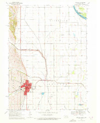
 1970 Nickerson NE1972 Print · USGSEastern Nebraska agricultural life is captured here just after the mid-century, showing the rural landscape of the Burt Co and Washington Co border. Genealogists can locate family landmarks like New England Cem and the Alder Grove Ch.
 - 1970 Map of Tekamah, 1972 Print
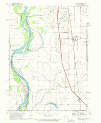
 1970 Tekamah1972 Print · USGSTekamah and the surrounding Nebraska-Iowa borderlands are captured here during a period of significant agricultural engineering in the early seventies. Genealogists and local historians can trace family plots at Tekamah Cemetery or locate civic roots near the Courthouse and the Chicago and North Western rail line.2 unique versions available
End of results
Showing maps 1-8 of 8
Top cities of Burt County
- Tekamah historical maps
- Oakland historical maps
- Lyons historical maps
- Decatur historical maps
- Arizona historical maps
- Craig historical maps
Frequently asked questions
- What are the different types of historical maps available for Burt County?
- What is the oldest map of Burt County?
- Where can I purchase historical maps of Burt County for my home or office?
- Where can I download high-res historical maps of Burt County?
- Are there historical topographic maps available for Burt County?
- Is there historical aerial imagery available for Burt County?
- Where are historical maps of Burt County sourced from?