
1970 Map of Oakland SE
USGS Topo · Published 1971About this map
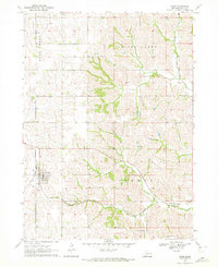
Craig serves as the primary settlement hub in this 1970 landscape, situated at the intersection of local routes and the Chicago and North Western railroad line. The terrain is defined by the drainage basins of Bell Creek and Silver Creek, which carve a detailed topography into the Burt County countryside. A notable point of genealogical interest is the Silver Creek Cem, which sits near the northern reaches of the eponymous waterway.
Find a feature on this map
8 named features on this map. Tap any name to fly to it.
Don’t see what you’re looking for? This feature index may not catch every label — zoom into the map to look around manually.
Map Details
Editions of this 1970 Oakland SE Map
2 editions found
Other maps of this area

1955 · Fremont
USGS Topo · 1:250,000

1957 · Fremont
USGS Topo · 1:250,000

1958 · Fremont
USGS Topo · 1:250,000

1966 · Oakland
USGS Topo · 1:24,000

1966 · Lyons
USGS Topo · 1:24,000

1966 · Nickerson NW
USGS Topo · 1:24,000
1970 · Tekamah NW
USGS Topo · 1:24,000
1970 · Bertha
USGS Topo · 1:24,000

1970 · Herman
USGS Topo · 1:24,000
1970 · Nickerson NE
USGS Topo · 1:24,000