1960s Maps of South Bend, Nebraska
Explore 3 historic maps of South Bend from the 1960s. These maps offer a rare glimpse into what life looked like during the 1960s — showing old roads, neighborhoods, homes, and landmarks that have changed or disappeared over time.
Whether you're researching your family's past, planning a metal detecting trip, or studying how South Bend's landscape evolved across the 1960s, these high-resolution maps are a powerful tool for exploring the history of this region.
- Focus on a specific era: All maps on this page are from the 1960s, giving you a focused view of this time period.
- See what’s changed: Compare century-old streets, trails, and buildings to today's modern landscape using overlays and satellite layers.
- Research with precision: Use these maps for genealogy, historical research, land use analysis, or educational projects.
- View, download, or print: Maps are fully viewable online in high resolution, and can be downloaded or printed for your own records.
Start exploring South Bend's history through authentic maps from the 1960s. This is your window into the past.
South Bend, NE maps
(3)- 1966 Map of Murdock, 1967 Print
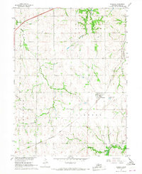 1966 Murdock1967 Print · USGSWestern Cass County's agricultural heartland is documented here in the mid-sixties, centered on the railroad junctions of Murdock and Wabash. Genealogists and local historians can trace family locations near the Wabash Cem, Trinity Ch, and the banks of Callahan Creek.2 unique versions available
 - 1966 Map of Manley, 1968 Print
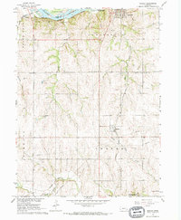 1966 Manley1968 Print · USGSCentral Cass County in the mid-1960s is defined by its strategic position between the Platte River and productive uplands. Researchers can locate family landmarks like St Patricks Cem, Dutch Sch, and the rail junction at Manley.
 - 1968 Map of Ashland East, 1970 Print
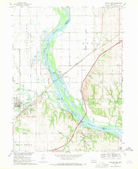 1968 Ashland East1970 Print · USGSThe Platte River valley in the late sixties shows a landscape shaped by river transport and military training. Genealogists and local historians can trace the foundations of Ashland or locate rural landmarks like Wortman Cem and the Camp Ashland military site.4 unique versions available
End of results
Showing maps 1-3 of 3
Top cities near South Bend
- Omaha historical maps
- Papillion historical maps
- La Vista historical maps
- Ralston historical maps
- Gretna historical maps
- Ashland historical maps
See more
Frequently asked questions
- What are the different types of historical maps available for South Bend?
- What is the oldest map of South Bend?
- Where can I purchase historical maps of South Bend for my home or office?
- Where can I download high-res historical maps of South Bend?
- Are there historical topographic maps available for South Bend?
- Is there historical aerial imagery available for South Bend?
- Where are historical maps of South Bend sourced from?