1990s Maps of Precinct 6, Nebraska
Explore 2 historic maps of Precinct 6 from the 1990s. These maps offer a rare glimpse into what life looked like during the 1990s — showing old roads, neighborhoods, homes, and landmarks that have changed or disappeared over time.
Whether you're researching your family's past, planning a metal detecting trip, or studying how Precinct 6's landscape evolved across the 1990s, these high-resolution maps are a powerful tool for exploring the history of this region.
- Focus on a specific era: All maps on this page are from the 1990s, giving you a focused view of this time period.
- See what’s changed: Compare century-old streets, trails, and buildings to today's modern landscape using overlays and satellite layers.
- Research with precision: Use these maps for genealogy, historical research, land use analysis, or educational projects.
- View, download, or print: Maps are fully viewable online in high resolution, and can be downloaded or printed for your own records.
Start exploring Precinct 6's history through authentic maps from the 1990s. This is your window into the past.
Precinct 6, NE maps
(2)- 1994 Map of St. Helena, 1995 Print
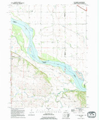 1994 St. Helena1995 Print · USGSThe Nebraska-South Dakota border along the Missouri River is captured here in the early nineties, revealing a landscape of shifting chutes and islands. Researchers can locate the St Helena Cem, the historic site of Bow Valley Mills, and the complex drainage of West Bow Creek.
 - 1994 Map of Meckling, 1995 Print
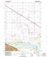 1994 Meckling1995 Print · USGSThe South Dakota and Nebraska borderlands come into focus in the 1990s as the Missouri River winds past Meckling. Genealogists can trace local roots at Bergen Ch or search for family sites at Evergreen Cem and Taylor Cem.
End of results
Showing maps 1-2 of 2
Top cities near Precinct 6
- Vermillion historical maps
- Hartington historical maps
- Gayville historical maps
- Newcastle historical maps
- Meckling historical maps
- Volin historical maps
See more
Frequently asked questions
- What are the different types of historical maps available for Precinct 6?
- What is the oldest map of Precinct 6?
- Where can I purchase historical maps of Precinct 6 for my home or office?
- Where can I download high-res historical maps of Precinct 6?
- Are there historical topographic maps available for Precinct 6?
- Is there historical aerial imagery available for Precinct 6?
- Where are historical maps of Precinct 6 sourced from?