1960s Maps of Precinct 9, Nebraska
Explore 4 historic maps of Precinct 9 from the 1960s. These maps offer a rare glimpse into what life looked like during the 1960s — showing old roads, neighborhoods, homes, and landmarks that have changed or disappeared over time.
Whether you're researching your family's past, planning a metal detecting trip, or studying how Precinct 9's landscape evolved across the 1960s, these high-resolution maps are a powerful tool for exploring the history of this region.
- Focus on a specific era: All maps on this page are from the 1960s, giving you a focused view of this time period.
- See what’s changed: Compare century-old streets, trails, and buildings to today's modern landscape using overlays and satellite layers.
- Research with precision: Use these maps for genealogy, historical research, land use analysis, or educational projects.
- View, download, or print: Maps are fully viewable online in high resolution, and can be downloaded or printed for your own records.
Start exploring Precinct 9's history through authentic maps from the 1960s. This is your window into the past.
Precinct 9, NE maps
(4)- 1968 Map of Coleridge, 1971 Print
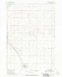 1968 Coleridge1971 Print · USGSThe village of Coleridge stands as a rail-side hub in late 1960s Cedar County, where the plains meet a intricate network of prairie creeks. Researchers can trace family ties at St Michael Cem and Immanuel Cem or follow the Chicago and North Western line.
 - 1968 Map of Hartington, 1971 Print
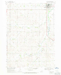 1968 Hartington1971 Print · USGSCedar County's county seat is shown in the late sixties as a thriving hub of rail and road. Genealogists and researchers can trace the locations of St Michaels Cem, Robins Sch, and the local Drive-in Theater near the Hartington town site.
 - 1968 Map of Wynot, 1971 Print
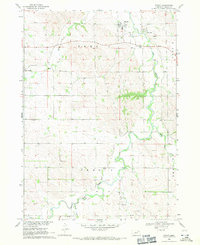 1968 Wynot1971 Print · USGSNortheastern Nebraska's creek valleys were captured in detail during the late sixties, showing the rural communities of Wynot and St James. Researchers can trace old property boundaries and locate local landmarks like Paragon Cem and several Gravel Pits along Bow Creek.
 - 1968 Map of Fordyce, 1971 Print
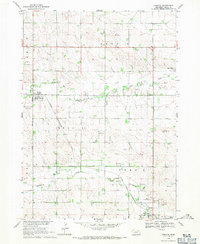 1968 Fordyce1971 Print · USGSCedar County's agricultural heartland is documented here in the late sixties, centered on the rail-dependent town of Fordyce. Genealogists and historians can trace the Chicago and North Western line as it connects Hartington to Bow Valley.
End of results
Showing maps 1-4 of 4
Top cities near Precinct 9
- Yankton historical maps
- Hartington historical maps
- Laurel historical maps
- Crofton historical maps
- Wausa historical maps
- Coleridge historical maps
See more
Frequently asked questions
- What are the different types of historical maps available for Precinct 9?
- What is the oldest map of Precinct 9?
- Where can I purchase historical maps of Precinct 9 for my home or office?
- Where can I download high-res historical maps of Precinct 9?
- Are there historical topographic maps available for Precinct 9?
- Is there historical aerial imagery available for Precinct 9?
- Where are historical maps of Precinct 9 sourced from?