1970s Maps of Wauneta, Nebraska
Explore 3 historic maps of Wauneta from the 1970s. These maps offer a rare glimpse into what life looked like during the 1970s — showing old roads, neighborhoods, homes, and landmarks that have changed or disappeared over time.
Whether you're researching your family's past, planning a metal detecting trip, or studying how Wauneta's landscape evolved across the 1970s, these high-resolution maps are a powerful tool for exploring the history of this region.
- Focus on a specific era: All maps on this page are from the 1970s, giving you a focused view of this time period.
- See what’s changed: Compare century-old streets, trails, and buildings to today's modern landscape using overlays and satellite layers.
- Research with precision: Use these maps for genealogy, historical research, land use analysis, or educational projects.
- View, download, or print: Maps are fully viewable online in high resolution, and can be downloaded or printed for your own records.
Start exploring Wauneta's history through authentic maps from the 1970s. This is your window into the past.
Wauneta, NE maps
(3)- 1974 Map of Wauneta West, 1977 Print
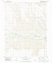 1974 Wauneta West1977 Print · USGSChase County agricultural life and transit corridors are well-defined in the mid-1970s as the railroad follows the valley floor. Trace the community footprint of Wauneta alongside Frenchman Creek, the Burlington Northern tracks, and Riverside Cem.
 - 1974 Map of Wauneta East, 1977 Print
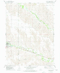 1974 Wauneta East1977 Print · USGSNear the Chase and Hayes county line in the mid-1970s, the village of Wauneta thrives along the rail and river corridors of the Nebraska plains. Local researchers can trace the Burlington Northern rail line as it follows Frenchman Creek past several Radio Towers and deep draws like Trail Canyon.
 - 1979 Map of Benkelman
 1979 Benkelman1979 Print · USGSSouthwestern Nebraska in the late seventies is shown as a network of river-valley towns and high-plains ranching country. Genealogists and researchers can trace the rail corridor through Benkelman, Culbertson, and Haigler, or locate the reservoir lands at Enders.
End of results
Showing maps 1-3 of 3
Top cities near Wauneta
Frequently asked questions
- What are the different types of historical maps available for Wauneta?
- What is the oldest map of Wauneta?
- Where can I purchase historical maps of Wauneta for my home or office?
- Where can I download high-res historical maps of Wauneta?
- Are there historical topographic maps available for Wauneta?
- Is there historical aerial imagery available for Wauneta?
- Where are historical maps of Wauneta sourced from?