Old Maps of Arabia, Nebraska for Hiking & Exploration
Hike through history with 9 historic maps of Arabia. Explore old trails, ghost towns, and forgotten backroads — perfect for outdoor adventurers and local explorers.
- Rediscover forgotten places: Map out old mining camps, roads, and footpaths that no longer exist on modern maps.
- Layer with modern tools: Combine with LiDAR or satellite views to plan hikes through historical terrain.
- Made for exploration: Popular among hikers, overlanders, and local history lovers.
Use these maps to find adventure and explore the hidden past of Arabia.
Arabia, NE maps
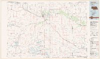
(9)- 1950 Map of Arabia, 1952 Print
 1950 Arabia1952 Print · USGSCherry County ranching and rail life are preserved here at mid-century, centered on the Arabia railroad siding. Researchers can trace the legacy of early education and land use through numerous sites like School No 181, Rolling Stone Ranch, and Fairfield.
 - 1957 Map of Valentine, 1960 Print
 1957 Valentine1960 Print · USGSNorthern Nebraska's ranching country and the vast Sand Hills are detailed here in the late fifties. Genealogists and historians can locate numerous family-named landmarks like the Dahlgren Ranch and trace the path of the Chicago and North Western railroad through Valentine.3 unique versions available
 - 1959 Map of Valentine
 1959 Valentine1959 Print · USGSThe northern Nebraska Sand Hills are captured here in the late fifties, showcasing a vast ranching landscape shaped by the Niobrara and Loup rivers. Genealogists and historians can trace rail-town development along the Chicago and North Western and locate remote outposts like Brownlee or Kennedy.
 - 1985 Map of Arabia
 1985 Arabia1985 Print · USGSThe Nebraska Sandhills near the settlement of Arabia are captured here in the mid-1980s, showcasing a landscape of rail and ranching. Researchers can trace the path of the Chicago and North Western railroad and the extensive Ainsworth Canal.
 - 1985 Map of Valentine
 1985 Valentine1985 Print · USGSThe Nebraska Sandhills in the mid-1980s reveal a landscape of vast wildlife refuges and rail-linked prairie towns. Researchers can trace the Chicago and North Western corridor through Kilgore and Valentine or locate remote landmarks like Snake River Falls.2 unique versions available
 - 2011 Map of Arabia, 2011 Print
 2011 Arabia2011 Print · USGSCovers Arabia, including Cherry County, United States, and other nearby areas
 - 2014 Map of Arabia, 2014 Print
 2014 Arabia2014 Print · USGSCovers Arabia, including Cherry County, United States, and other nearby areas
 - 2017 Map of Arabia, 2017 Print
 2017 Arabia2017 Print · USGSCovers Arabia, including Cherry County, United States, and other nearby areas
 - 2021 Map of Arabia, 2021 Print
 2021 Arabia2021 Print · USGSNorthwestern Nebraska's ranching country is captured here during the early twenty-first century, showcasing a landscape of isolated settlements and vital water infrastructure. You can trace the path of the Cowboy Trl near Arabia or locate the Ainsworth Canal and O'Kief Reservoir.
End of results
Showing maps 1-9 of 9
Top cities near Arabia
Frequently asked questions
- What are the different types of historical maps available for Arabia?
- What is the oldest map of Arabia?
- Where can I purchase historical maps of Arabia for my home or office?
- Where can I download high-res historical maps of Arabia?
- Are there historical topographic maps available for Arabia?
- Is there historical aerial imagery available for Arabia?
- Where are historical maps of Arabia sourced from?