1980s Maps of Cody, Nebraska
Explore 3 historic maps of Cody from the 1980s. These maps offer a rare glimpse into what life looked like during the 1980s — showing old roads, neighborhoods, homes, and landmarks that have changed or disappeared over time.
Whether you're researching your family's past, planning a metal detecting trip, or studying how Cody's landscape evolved across the 1980s, these high-resolution maps are a powerful tool for exploring the history of this region.
- Focus on a specific era: All maps on this page are from the 1980s, giving you a focused view of this time period.
- See what’s changed: Compare century-old streets, trails, and buildings to today's modern landscape using overlays and satellite layers.
- Research with precision: Use these maps for genealogy, historical research, land use analysis, or educational projects.
- View, download, or print: Maps are fully viewable online in high resolution, and can be downloaded or printed for your own records.
Start exploring Cody's history through authentic maps from the 1980s. This is your window into the past.
Cody, NE maps
(3)- 1985 Map of Cody East
 1985 Cody East1985 Print · USGSCherry County rangelands and the South Dakota border come into focus in the mid-1980s. Genealogists and local historians can trace the community of Cody, the Prairie Lawn Cem, and established family holdings like Metz Ranch.
 - 1985 Map of Cody
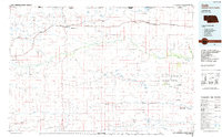 1985 Cody1985 Print · USGSThe Nebraska Sandhills and the South Dakota borderlands are captured here in the mid-1980s, centered on the Chicago and North Western rail corridor. Genealogists and local historians can trace small-town development in Cody and Merriman or locate rural landmarks within the Samuel R McKelvie National Forest.
 - 1985 Map of Cody West
 1985 Cody West1985 Print · USGSCherry County ranching and the Nebraska-South Dakota borderlands are captured here in the mid-1980s. Researchers can trace the heritage of local cattle operations like Duck Brand Ranch or locate water features such as Cody Lake and Hay Creek.
End of results
Showing maps 1-3 of 3
Top cities near Cody
Frequently asked questions
- What are the different types of historical maps available for Cody?
- What is the oldest map of Cody?
- Where can I purchase historical maps of Cody for my home or office?
- Where can I download high-res historical maps of Cody?
- Are there historical topographic maps available for Cody?
- Is there historical aerial imagery available for Cody?
- Where are historical maps of Cody sourced from?