Old Maps of Cody, Nebraska for Academic Research
Study the evolution of Cody with 16 high-resolution historic maps. Whether you're teaching, researching, or modeling changes in land use, these maps provide essential visual documentation of urban, environmental, and geographic change.
- Analyze long-term change: Track patterns in development, transportation, and natural features.
- Ideal for environmental or urban studies: Support academic projects with primary historical map data.
- Use in the classroom or lab: Educators and researchers rely on these maps to bring historical context to life.
These maps are a powerful tool for teaching, research, and visualizing how Cody has changed over the decades.
Cody, NE maps
(16)- 1950 Map of Cody, 1952 Print
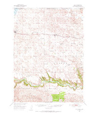 1950 Cody1952 Print · USGSCherry County ranching and rail life are at the forefront here in the early fifties as the railroad connects isolated outposts. Researchers can trace historic family lands like the Goodwin Ranch or locate vanished rural schoolhouses such as Crackerbox Sch and School No 60.2 unique versions available
 - 1952 Map of Eli
 1952 Eli1952 Print · USGSThe Niobrara River valley and the surrounding Sand Hills of northern Nebraska are shown here in the early fifties. Local historians can trace the routes of the Chicago and North Western rail line and locate rural sites like Boiling Spring Sch and the Eli Cem.
 - 1957 Map of Valentine, 1960 Print
 1957 Valentine1960 Print · USGSNorthern Nebraska's ranching country and the vast Sand Hills are detailed here in the late fifties. Genealogists and historians can locate numerous family-named landmarks like the Dahlgren Ranch and trace the path of the Chicago and North Western railroad through Valentine.3 unique versions available
 - 1959 Map of Valentine
 1959 Valentine1959 Print · USGSThe northern Nebraska Sand Hills are captured here in the late fifties, showcasing a vast ranching landscape shaped by the Niobrara and Loup rivers. Genealogists and historians can trace rail-town development along the Chicago and North Western and locate remote outposts like Brownlee or Kennedy.
 - 1985 Map of Cody East
 1985 Cody East1985 Print · USGSCherry County rangelands and the South Dakota border come into focus in the mid-1980s. Genealogists and local historians can trace the community of Cody, the Prairie Lawn Cem, and established family holdings like Metz Ranch.
 - 1985 Map of Cody
 1985 Cody1985 Print · USGSThe Nebraska Sandhills and the South Dakota borderlands are captured here in the mid-1980s, centered on the Chicago and North Western rail corridor. Genealogists and local historians can trace small-town development in Cody and Merriman or locate rural landmarks within the Samuel R McKelvie National Forest.
 - 1985 Map of Cody West
 1985 Cody West1985 Print · USGSCherry County ranching and the Nebraska-South Dakota borderlands are captured here in the mid-1980s. Researchers can trace the heritage of local cattle operations like Duck Brand Ranch or locate water features such as Cody Lake and Hay Creek.
 - 1994 Map of Cody
 1994 Cody1994 Print · USGSThe Nebraska Sandhills and South Dakota borderlands are captured here in the mid-nineties, showing the vast ranching country around the Niobrara River. Local historians can trace early settlements like Eli and Lavaca alongside the borders of the Samuel R Mc Kelvie National Forest.
 - 2011 Map of Cody East, 2011 Print
 2011 Cody East2011 Print · USGSCovers Cody, including Martin, Spring Creek Segment, and other nearby areas
 - 2011 Map of Cody West, 2011 Print
 2011 Cody West2011 Print · USGSCovers Cody, including Martin, Cherry County, and other nearby areas
 - 2014 Map of Cody East, 2014 Print
 2014 Cody East2014 Print · USGSCovers Cody, including Martin, Spring Creek Segment, and other nearby areas
 - 2014 Map of Cody West, 2014 Print
 2014 Cody West2014 Print · USGSCovers Cody, including Martin, Cherry County, and other nearby areas
 - 2017 Map of Cody West, 2017 Print
 2017 Cody West2017 Print · USGSCovers Cody, including Martin, Cherry County, and other nearby areas
 - 2017 Map of Cody East, 2017 Print
 2017 Cody East2017 Print · USGSCovers Cody, including Martin, Spring Creek Segment, and other nearby areas
 - 2021 Map of Cody East, 2021 Print
 2021 Cody East2021 Print · USGSThe Nebraska Sandhills meet the South Dakota border in this recent survey of eastern Cherry County. Genealogists and local historians can trace the town grid along Cody Ave and locate burials at Prairie Lawn Cem or follow the path of the Cowboy Trl.
 - 2021 Map of Cody West, 2021 Print
 2021 Cody West2021 Print · USGSCherry County at the turn of the decade shows the quiet transition of Nebraska rail country into recreation. Trace the path of the Cowboy Trl past Cody toward the waters of Cody Lake and Hay Cr.
End of results
Showing maps 1-16 of 16
Top cities near Cody
Frequently asked questions
- What are the different types of historical maps available for Cody?
- What is the oldest map of Cody?
- Where can I purchase historical maps of Cody for my home or office?
- Where can I download high-res historical maps of Cody?
- Are there historical topographic maps available for Cody?
- Is there historical aerial imagery available for Cody?
- Where are historical maps of Cody sourced from?