Old Maps of Conterra, Nebraska for Academic Research
Study the evolution of Conterra with 9 high-resolution historic maps. Whether you're teaching, researching, or modeling changes in land use, these maps provide essential visual documentation of urban, environmental, and geographic change.
- Analyze long-term change: Track patterns in development, transportation, and natural features.
- Ideal for environmental or urban studies: Support academic projects with primary historical map data.
- Use in the classroom or lab: Educators and researchers rely on these maps to bring historical context to life.
These maps are a powerful tool for teaching, research, and visualizing how Conterra has changed over the decades.
Conterra, NE maps
(9)- 1951 Map of Brownlee
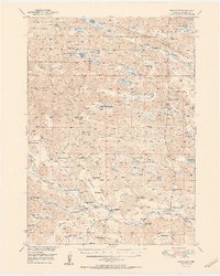 1951 Brownlee1951 Print · USGSThe Nebraska Sandhills come alive in this mid-century survey of Cherry County, showing a landscape defined by cattle ranching and expansive wildlife wetlands. Researchers can locate family landmarks like the F Hanna Ranch, School No 37, and the winding Goose Creek.2 unique versions available
 - 1957 Map of Valentine, 1960 Print
 1957 Valentine1960 Print · USGSNorthern Nebraska's ranching country and the vast Sand Hills are detailed here in the late fifties. Genealogists and historians can locate numerous family-named landmarks like the Dahlgren Ranch and trace the path of the Chicago and North Western railroad through Valentine.3 unique versions available
 - 1959 Map of Valentine
 1959 Valentine1959 Print · USGSThe northern Nebraska Sand Hills are captured here in the late fifties, showcasing a vast ranching landscape shaped by the Niobrara and Loup rivers. Genealogists and historians can trace rail-town development along the Chicago and North Western and locate remote outposts like Brownlee or Kennedy.
 - 1985 Map of Goose Creek
 1985 Goose Creek1985 Print · USGSCentral Nebraska's Sandhills come into focus in the mid-eighties, showing a landscape of remote ranching outposts and wildlife preserves. Trace old rail routes and rural settlements like Brownlee, Seneca, and Purdum along the Goose Creek watershed.2 unique versions available
 - 1985 Map of Mule Lake, 1986 Print
 1985 Mule Lake1986 Print · USGSThe Nebraska Sandhills come alive in this mid-1980s study of the remote ranching country in Cherry County. Genealogists and researchers can trace family-named sites like Daniels Ranch and Pearson Ranch set among the waters of Mule Lake.
 - 2011 Map of Mule Lake, 2011 Print
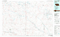
 2011 Mule Lake2011 Print · USGSCovers Conterra, including Cherry County, United States, and other nearby areas
 - 2014 Map of Mule Lake, 2014 Print
 2014 Mule Lake2014 Print · USGSCovers Conterra, including Cherry County, United States, and other nearby areas
 - 2017 Map of Mule Lake, 2017 Print
 2017 Mule Lake2017 Print · USGSCovers Conterra, including Cherry County, United States, and other nearby areas
 - 2021 Map of Mule Lake, 2021 Print
 2021 Mule Lake2021 Print · USGSIn the Nebraska Sandhills during the early 2020s, this area is defined by its unique network of high plains lakes. Researchers can trace the local landscape around Conterra and study the shorelines of Mule Lake, Beaver Lake, and Rat Lake.
End of results
Showing maps 1-9 of 9
Frequently asked questions
- What are the different types of historical maps available for Conterra?
- What is the oldest map of Conterra?
- Where can I purchase historical maps of Conterra for my home or office?
- Where can I download high-res historical maps of Conterra?
- Are there historical topographic maps available for Conterra?
- Is there historical aerial imagery available for Conterra?
- Where are historical maps of Conterra sourced from?