Old Maps of Elsmere, Nebraska for Genealogy
Trace your family roots with 10 historic maps of Elsmere. These high-res maps reveal old neighborhoods, homesites, landmarks, and streets — helping you uncover where your ancestors lived and how the area evolved over time.
- Explore historic neighborhoods: Identify where your relatives may have lived in the 1800s or 1900s.
- Compare maps over time: Trace the changes in streets, buildings, and landmarks for multi-generational research.
- Perfect for genealogy & ancestry research: Used by family historians and researchers to map out lineage and migration.
These maps are an incredible resource for exploring your personal connection to Elsmere's past.
Elsmere, NE maps
(10)- 1949 Map of Koshopah, 1976 Print
 1949 Koshopah1976 Print · USGSThe Nebraska Sandhills ranching country is captured here during the post-war era, showing the intersection of three counties. Genealogists can trace family holdings and local landmarks like White Ranch, Koshopah, and the many rural schools including Pixley Sch.
 - 1951 Map of Koshopah
 1951 Koshopah1951 Print · USGSMid-century ranching life in Brown, Cherry, and Blaine Counties is documented here just after the war. Researchers can locate numerous family holdings and rural schoolhouses like Pixley Sch, Giles Cem, and O Teaford Ranch.
 - 1957 Map of Valentine, 1960 Print
 1957 Valentine1960 Print · USGSNorthern Nebraska's ranching country and the vast Sand Hills are detailed here in the late fifties. Genealogists and historians can locate numerous family-named landmarks like the Dahlgren Ranch and trace the path of the Chicago and North Western railroad through Valentine.3 unique versions available
 - 1959 Map of Valentine
 1959 Valentine1959 Print · USGSThe northern Nebraska Sand Hills are captured here in the late fifties, showcasing a vast ranching landscape shaped by the Niobrara and Loup rivers. Genealogists and historians can trace rail-town development along the Chicago and North Western and locate remote outposts like Brownlee or Kennedy.
 - 1985 Map of Goose Creek
 1985 Goose Creek1985 Print · USGSCentral Nebraska's Sandhills come into focus in the mid-eighties, showing a landscape of remote ranching outposts and wildlife preserves. Trace old rail routes and rural settlements like Brownlee, Seneca, and Purdum along the Goose Creek watershed.2 unique versions available
 - 1986 Map of Elsmere
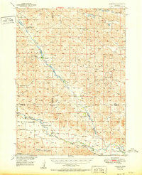
 1986 Elsmere1986 Print · USGSThe remote Sandhills of Cherry and Brown counties are captured here in the mid-1980s, centered on the small settlement of Elsmere. Researchers can trace the importance of groundwater through numerous Flowing Wells and individual Wells scattered along Goose Creek.
 - 2011 Map of Elsmere, 2011 Print
 2011 Elsmere2011 Print · USGSCovers Elsmere, including Cherry County, Brown County, and other nearby areas
 - 2014 Map of Elsmere, 2014 Print
 2014 Elsmere2014 Print · USGSCovers Elsmere, including Cherry County, Brown County, and other nearby areas
 - 2017 Map of Elsmere, 2017 Print
 2017 Elsmere2017 Print · USGSCovers Elsmere, including Cherry County, Brown County, and other nearby areas
 - 2021 Map of Elsmere, 2021 Print
 2021 Elsmere2021 Print · USGSCherry County ranching country is documented in the early 2020s as it centers on the small community of Elsmere. Researchers can trace local lineage at Giles Cem or follow the waters of Goose Cr through the shifting sands of the Nebraska interior.
End of results
Showing maps 1-10 of 10
Frequently asked questions
- What are the different types of historical maps available for Elsmere?
- What is the oldest map of Elsmere?
- Where can I purchase historical maps of Elsmere for my home or office?
- Where can I download high-res historical maps of Elsmere?
- Are there historical topographic maps available for Elsmere?
- Is there historical aerial imagery available for Elsmere?
- Where are historical maps of Elsmere sourced from?