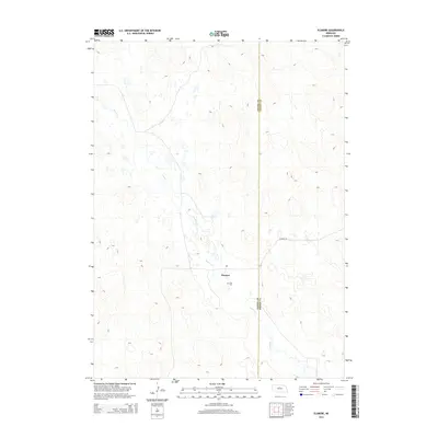
2014 Map of Elsmere
USGS Topo · Published 2014About this map
Goose Cr winds through the heart of the Sandhills region, defining the drainage patterns and local geography of this Nebraska landscape. The small settlement of Elsmere sits as a primary point of interest, anchored by a Po and connected to the wider region via Elsmere Rd. For those researching local family histories, the inclusion of the Giles Cem south of the town site offers a specific landmark for genealogical study. The map also delineates the jurisdictional boundary between Cherry Co and Brown Co, which runs vertically through the eastern portion of the quadrangle, influencing local land records and administrative history.
Find a feature on this map
6 named features on this map. Tap any name to fly to it.
Don’t see what you’re looking for? This feature index may not catch every label — zoom into the map to look around manually.
Map Details
Editions of this 2014 Elsmere Map
This is the sole edition of this map. No revisions or reprints were ever made.
Other maps of this area
1949 · Purdum
USGS Topo · 1:62,500

1949 · Koshopah
USGS Topo · 1:62,500
1949 · Long Lake
USGS Topo · 1:62,500
1951 · Long Lake
USGS Topo · 1:62,500
1951 · Purdum
USGS Topo · 1:62,500
1951 · Moon Lake
USGS Topo · 1:62,500
1951 · Koshopah
USGS Topo · 1:62,500
1957 · Valentine
USGS Topo · 1:250,000
1959 · Valentine
USGS Topo · 1:250,000
1985 · Long Lake SE
USGS Topo · 1:24,000