1900s (20th Century) Maps of Sargent, Nebraska
Explore 6 historic maps of Sargent from the 1900s (20th Century). These maps offer a rare glimpse into what life looked like during the 1900s — showing old roads, neighborhoods, homes, and landmarks that have changed or disappeared over time.
Whether you're researching your family's past, planning a metal detecting trip, or studying how Sargent's landscape evolved across the 1900s, these high-resolution maps are a powerful tool for exploring the history of this region.
- Focus on a specific era: All maps on this page are from the 1900s, giving you a focused view of this time period.
- See what’s changed: Compare century-old streets, trails, and buildings to today's modern landscape using overlays and satellite layers.
- Research with precision: Use these maps for genealogy, historical research, land use analysis, or educational projects.
- View, download, or print: Maps are fully viewable online in high resolution, and can be downloaded or printed for your own records.
Start exploring Sargent's history through authentic maps from the 1900s. This is your window into the past.
Sargent, NE maps
(6)- 1952 Map of Sargent East, 1954 Print
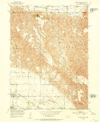 1952 Sargent East1954 Print · USGSCuster County agriculture and irrigation infrastructure are on full display in the early fifties, centered on the community of Sargent. Family historians can trace local schoolhouses like North Star Sch and Phillipsburg Sch or the rail path of the Chicago Burlington and Quincy.3 unique versions available
 - 1952 Map of Sargent West, 1954 Print
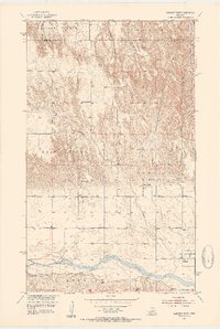 1952 Sargent West1954 Print · USGSCuster County life in the early fifties was centered on the river valley and a network of rural school districts. Genealogists can trace family footprints through sites like West Union Cem, Zion Hill Sch, and the township of Madison Square.4 unique versions available
 - 1955 Map of Broken Bow
 1955 Broken Bow1955 Print · USGSCentral Nebraska in the mid-fifties is defined by the sweeping Sand Hills and the vital river valleys that supported its ranching and rail towns. Researchers can trace the rail corridors of the Union Pacific RR and locate settlements like Dannebrog, Broken Bow, and Brewster.5 unique versions available
 - 1956 Map of Broken Bow
 1956 Broken Bow1956 Print · USGSCentral Nebraska during the mid-fifties reveals a region defined by its river-valley railroads and the rolling Sand Hills. Genealogists and local historians can trace the paths of the Chicago Burlington and Quincy through towns like Broken Bow, Merna, and Anselmo.
 - 1985 Map of Burwell
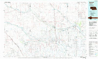 1985 Burwell1985 Print · USGSCentral Nebraska in the mid-eighties reveals a landscape shaped by the Middle Loup River and the Burlington Northern rail line. Researchers can trace the layout of small towns like Sargent, Anselmo, and Burwell or locate New Helena and Victoria Springs State Recreation Area.
 - 1994 Map of Burwell
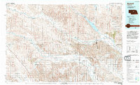 1994 Burwell1994 Print · USGSThe Nebraska Sandhills region is captured here in the mid-nineties, showing a landscape shaped by the Loup River systems and vital irrigation networks. Researchers can trace the development of small towns like Burwell and Brewster or locate landmarks like the Milburn Diversion Dam.
End of results
Showing maps 1-6 of 6
Top cities near Sargent
Frequently asked questions
- What are the different types of historical maps available for Sargent?
- What is the oldest map of Sargent?
- Where can I purchase historical maps of Sargent for my home or office?
- Where can I download high-res historical maps of Sargent?
- Are there historical topographic maps available for Sargent?
- Is there historical aerial imagery available for Sargent?
- Where are historical maps of Sargent sourced from?