1900s (20th Century) Maps of Eddyville, Nebraska
Explore 5 historic maps of Eddyville from the 1900s (20th Century). These maps offer a rare glimpse into what life looked like during the 1900s — showing old roads, neighborhoods, homes, and landmarks that have changed or disappeared over time.
Whether you're researching your family's past, planning a metal detecting trip, or studying how Eddyville's landscape evolved across the 1900s, these high-resolution maps are a powerful tool for exploring the history of this region.
- Focus on a specific era: All maps on this page are from the 1900s, giving you a focused view of this time period.
- See what’s changed: Compare century-old streets, trails, and buildings to today's modern landscape using overlays and satellite layers.
- Research with precision: Use these maps for genealogy, historical research, land use analysis, or educational projects.
- View, download, or print: Maps are fully viewable online in high resolution, and can be downloaded or printed for your own records.
Start exploring Eddyville's history through authentic maps from the 1900s. This is your window into the past.
Eddyville, NE maps
(5)- 1951 Map of Eddyville, 1953 Print
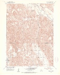 1951 Eddyville1953 Print · USGSDawson and Custer Counties appear here in the early fifties, showing a rural Nebraska landscape of railroad towns and upland ranching. Genealogists and local historians can locate early landmarks like Park Valley Cem and several country schools including Hidden Hollow Sch.2 unique versions available
 - 1951 Map of Eddyville SW, 1953 Print
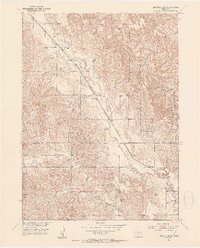 1951 Eddyville SW1953 Print · USGSCuster and Dawson Counties are captured here in the early fifties, dominated by the valley of the Wood River. Researchers can trace the Union Pacific rail line and locate rural landmarks like Happy Hollow Sch and Eddyville.3 unique versions available
 - 1955 Map of Broken Bow
 1955 Broken Bow1955 Print · USGSCentral Nebraska in the mid-fifties is defined by the sweeping Sand Hills and the vital river valleys that supported its ranching and rail towns. Researchers can trace the rail corridors of the Union Pacific RR and locate settlements like Dannebrog, Broken Bow, and Brewster.5 unique versions available
 - 1956 Map of Broken Bow
 1956 Broken Bow1956 Print · USGSCentral Nebraska during the mid-fifties reveals a region defined by its river-valley railroads and the rolling Sand Hills. Genealogists and local historians can trace the paths of the Chicago Burlington and Quincy through towns like Broken Bow, Merna, and Anselmo.
 - 1985 Map of Broken Bow
 1985 Broken Bow1985 Print · USGSCuster County in the mid-1980s displays a landscape of high tablelands and river valleys shaped by the reach of the railroad. Genealogists and researchers can trace the old rail stops along Mud Creek, from Berwyn to Litchfield, or locate land near Redfern Table and West Table.2 unique versions available
End of results
Showing maps 1-5 of 5
Top cities near Eddyville
Frequently asked questions
- What are the different types of historical maps available for Eddyville?
- What is the oldest map of Eddyville?
- Where can I purchase historical maps of Eddyville for my home or office?
- Where can I download high-res historical maps of Eddyville?
- Are there historical topographic maps available for Eddyville?
- Is there historical aerial imagery available for Eddyville?
- Where are historical maps of Eddyville sourced from?