1960s Maps of Fremont, Nebraska
Explore 2 historic maps of Fremont from the 1960s. These maps offer a rare glimpse into what life looked like during the 1960s — showing old roads, neighborhoods, homes, and landmarks that have changed or disappeared over time.
Whether you're researching your family's past, planning a metal detecting trip, or studying how Fremont's landscape evolved across the 1960s, these high-resolution maps are a powerful tool for exploring the history of this region.
- Focus on a specific era: All maps on this page are from the 1960s, giving you a focused view of this time period.
- See what’s changed: Compare century-old streets, trails, and buildings to today's modern landscape using overlays and satellite layers.
- Research with precision: Use these maps for genealogy, historical research, land use analysis, or educational projects.
- View, download, or print: Maps are fully viewable online in high resolution, and can be downloaded or printed for your own records.
Start exploring Fremont's history through authentic maps from the 1960s. This is your window into the past.
Fremont, NE maps
(2)- 1968 Map of Fremont West, 1971 Print
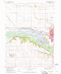 1968 Fremont West1971 Print · USGSMid-century Nebraska life unfolds along the Platte River during the late sixties, where recreation lakes and heavy rail lines meet. Genealogists can locate family burial sites at Pohocco Cem and Wiegand Cem or trace early school districts at Beebe Sch.2 unique versions available
 - 1968 Map of Fremont East, 1971 Print
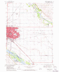 1968 Fremont East1971 Print · USGSThe rail and river networks of eastern Nebraska converged here in the late sixties, showing a period of significant civic and industrial growth. Researchers can trace family roots through numerous neighborhood landmarks like St Patricks Sch, Midland College, and Ruwe Park.3 unique versions available
End of results
Showing maps 1-2 of 2
Top cities near Fremont
- Omaha historical maps
- Wahoo historical maps
- Valley historical maps
- Yutan historical maps
- Arlington historical maps
- Scribner historical maps
See more
Top neighborhoods of Fremont
Frequently asked questions
- What are the different types of historical maps available for Fremont?
- What is the oldest map of Fremont?
- Where can I purchase historical maps of Fremont for my home or office?
- Where can I download high-res historical maps of Fremont?
- Are there historical topographic maps available for Fremont?
- Is there historical aerial imagery available for Fremont?
- Where are historical maps of Fremont sourced from?