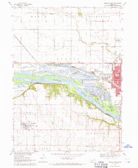
1968 Map of Fremont West
USGS Topo · Published 1971About this map
Platte River islands and braided channels dominate this landscape, which reveals a complex network of sand pits and recreation lakes just west of Fremont. The 1968 field survey shows a region defined by its water management and leisure sites, from the Fremont Cutoff Ditch to a cluster of riverside retreats including Summer Haven Lake, Leisure Lake, and Rainbow Lake. The transportation infrastructure of the era is clearly marked by the Union Pacific and Chicago and North Western lines, alongside an Old Railroad Grade that hints at earlier transit corridors.
Find a feature on this map
62 named features on this map. Tap any name to fly to it.
Don’t see what you’re looking for? This feature index may not catch every label — zoom into the map to look around manually.
Map Details
Editions of this 1968 Fremont West Map
2 editions found
Other maps of this area

1893 · Fremont
USGS Topo · 1:125,000

1896 · Fremont
USGS Topo · 1:125,000

1899 · Wahoo
USGS Topo · 1:125,000

1955 · Fremont
USGS Topo · 1:250,000

1957 · Fremont
USGS Topo · 1:250,000

1958 · Fremont
USGS Topo · 1:250,000

1966 · Scribner SW
USGS Topo · 1:24,000

1966 · Nickerson
USGS Topo · 1:24,000

1966 · Hooper
USGS Topo · 1:24,000

1968 · Leshara
USGS Topo · 1:24,000