1950s Maps of Grant County, Nebraska
Explore 21 historic maps of Grant County from the 1950s. These maps offer a rare glimpse into what life looked like during the 1950s — showing old roads, neighborhoods, homes, and landmarks that have changed or disappeared over time.
Whether you're researching your family's past, planning a metal detecting trip, or studying how Grant County's landscape evolved across the 1950s, these high-resolution maps are a powerful tool for exploring the history of this region.
- Focus on a specific era: All maps on this page are from the 1950s, giving you a focused view of this time period.
- See what’s changed: Compare century-old streets, trails, and buildings to today's modern landscape using overlays and satellite layers.
- Research with precision: Use these maps for genealogy, historical research, land use analysis, or educational projects.
- View, download, or print: Maps are fully viewable online in high resolution, and can be downloaded or printed for your own records.
Start exploring Grant County's history through authentic maps from the 1950s. This is your window into the past.
Grant County, NE maps
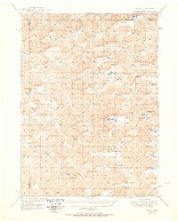
(21)- 1950 Map of Flats
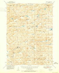
 1950 Flats1950 Print · USGSMcPherson County and the surrounding Sandhills were defined by isolated cattle operations and small rural school districts at the midpoint of the century. Genealogists and local historians can trace family-named sites like Stickney Ranch, Wood Ranch, and School No 45.2 unique versions available
 - 1950 Map of Spring Valley
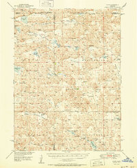
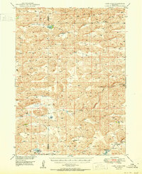
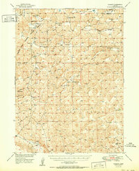
 1950 Spring Valley1950 Print · USGSGrant County is a mosaic of prairie valleys and ranching outposts in this mid-century survey of the Sandhills. Trace the locations of rural schools and isolated homesteads like School No 8, Rose Hill Sch, and landmarks including Egan Lake.2 unique versions available
 - 1950 Map of Velma
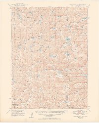
 1950 Velma1950 Print · USGSArthur and Grant Counties were centers of the Nebraska Sandhills ranching economy in the late 1940s. Genealogists and local historians can trace family-named landmarks like Beekins Ranch, Velma, and scattered schoolhouses such as School No 40.2 unique versions available
 - 1950 Map of Whitman
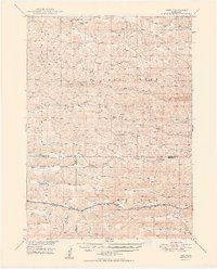
 1950 Whitman1950 Print · USGSMid-century Cherry County ranching culture is preserved here just as the post-war era was reshaping the Nebraska Sandhills. Genealogists and historians can trace the vast Rothwell Ranch, find the rural Red Mill School, and follow the Chicago Burlington and Quincy rail line.
 - 1950 Map of George Lake
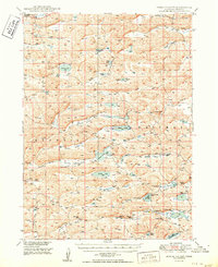
 1950 George Lake1950 Print · USGSGrant County ranching culture is on full display in this mid-century survey of the Nebraska sandhills around Hyannis. Genealogists can trace family holdings and rural landmarks like Merrihew Ranch, Locust Sch, and the isolated Lowes Camp.
 - 1950 Map of Carr Lake
 1950 Carr Lake1950 Print · USGSHooker County ranching and the high plains water network are captured in this mid-century survey. Genealogists can locate family-named landmarks and rural hubs like E Carr Ranch, Eclipse Ch, and the Tucker Sch along the Dismal River.2 unique versions available
 - 1950 Map of Arthur
 1950 Arthur1950 Print · USGSThe Nebraska Sandhills come into focus at mid-century, revealing a ranching landscape centered on the village of Arthur. Genealogists and historians can trace family-named landmarks like the Eymann Ranch and Anderberg Ranch or locate rural outposts like Meadow View Sch.2 unique versions available
 - 1950 Map of Longfellow Lake
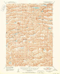
 1950 Longfellow Lake1950 Print · USGSGarden County ranching country is captured here during the mid-century, defined by the expansive Sandhills and the Crescent Lake National Wildlife Refuge. Researchers can trace rural school districts like School No 71 and family landmarks including Schmoker Valley and Potter Lake.3 unique versions available
 - 1950 Map of Hire
 1950 Hire1950 Print · USGSThe Nebraska Sandhills come into focus in the early fifties, where the Loup River branches converge at the Cherry and Hooker county lines. Genealogists can locate rural institutions like Cox Sch and the siding at Weir along the Chicago Burlington and Quincy rail line.3 unique versions available
 - 1950 Map of Bingham
 1950 Bingham1950 Print · USGSBingham and the surrounding ranchlands of Sheridan County are shown here in the mid-twentieth century as the railroad still anchored the Sandhills economy. Genealogists and local historians can trace family-named landmarks like Lambert Ranch and isolated rural schoolhouses including School No 156.
 - 1951 Map of Rackett
 1951 Rackett1951 Print · USGSGarden County ranching and the Sandhills frontier are preserved here just after the war, showing the isolated homesteads and school districts of central Nebraska. Genealogists can trace family holdings like Rounsburg Ranch and Smith Ranch or locate vanished landmarks like Well Valley Sch.2 unique versions available
 - 1954 Map of Scottsbluff, 1958 Print
 1954 Scottsbluff1958 Print · USGSThe Nebraska Panhandle's iconic landmarks and rail corridors are captured here during the mid-1950s. Researchers can trace the path of the North Platte River past Chimney Rock or locate the sprawling Sioux Ordnance Depot and the historic streets of Sidney.3 unique versions available
 - 1954 Map of North Platte, 1968 Print
 1954 North Platte1968 Print · USGSThe Nebraska Sand Hills and the Platte River valley are captured here during a period of mid-century growth and agricultural expansion. Trace the vast irrigation network of the Sutherland Canal, locate old rural schoolhouses like Rose Hill School, and find family holdings such as Conrey Ranch.3 unique versions available
 - 1955 Map of Alliance, 1966 Print
 1955 Alliance1966 Print · USGSThe Nebraska panhandle comes into sharp focus during the mid-fifties, showing a landscape defined by the Niobrara River and the expanding Sand Hills. Researchers can trace the grounds of Fort Robinson, locate Saint Marys Church, or follow the Chicago Burlington and Quincy rail line through Hemingford.3 unique versions available
 - 1956 Map of North Platte
 1956 North Platte1956 Print · USGSThe Nebraska Sand Hills meet the high plains river valleys in the mid-1950s, a period of intensive water management and rail commerce. Genealogists and historians can trace early prairie settlements like Stapleton and Tryon, or follow the industrial corridor of the Union Pacific through North Platte.
 - 1957 Map of North Platte
 1957 North Platte1957 Print · USGSThe Nebraska Sand Hills and the Platte River valley are captured here in the mid-fifties as the ranching and irrigation economy matured. Genealogists and historians can locate family-named schoolhouses like Maire School or trace the railroad hubs at North Platte and the Fort McPherson National Cemetery.
 - 1957 Map of Alliance
 1957 Alliance1957 Print · USGSNorthwest Nebraska in the mid-fifties is captured here as a landscape of rail hubs, sprawling cattle ranches, and the eastern edge of the dunes. Genealogists and historians can trace rail lines through Alliance and Chadron or locate landmarks like Saint Marys Church and the Agate Spring Fossil Beds.
 - 1957 Map of Valentine, 1960 Print
 1957 Valentine1960 Print · USGSNorthern Nebraska's ranching country and the vast Sand Hills are detailed here in the late fifties. Genealogists and historians can locate numerous family-named landmarks like the Dahlgren Ranch and trace the path of the Chicago and North Western railroad through Valentine.3 unique versions available
 - 1958 Map of Alliance
 1958 Alliance1958 Print · USGSNorthwestern Nebraska in the late fifties shows a landscape shaped by the legacy of the high plains frontier and modern agricultural expansion. Genealogists and historians can trace rail-line settlements and landmarks like Fort Robinson and the Agate Spring Fossil Beds.
 - 1958 Map of Scottsbluff
 1958 Scottsbluff1958 Print · USGSThe Nebraska panhandle in the late fifties was a vital corridor of rail-and-river transport defined by the North Platte River and the Union Pacific. Genealogists and historians can trace rail stops like Reddus Station, explore the grounds of the Sioux Ordnance Depot, or locate landmarks like Chimney Rock.2 unique versions available
 - 1959 Map of Valentine
 1959 Valentine1959 Print · USGSThe northern Nebraska Sand Hills are captured here in the late fifties, showcasing a vast ranching landscape shaped by the Niobrara and Loup rivers. Genealogists and historians can trace rail-town development along the Chicago and North Western and locate remote outposts like Brownlee or Kennedy.
End of results
Showing maps 1-21 of 21
Top cities of Grant County
Frequently asked questions
- What are the different types of historical maps available for Grant County?
- What is the oldest map of Grant County?
- Where can I purchase historical maps of Grant County for my home or office?
- Where can I download high-res historical maps of Grant County?
- Are there historical topographic maps available for Grant County?
- Is there historical aerial imagery available for Grant County?
- Where are historical maps of Grant County sourced from?