1800s (19th Century) Maps of Hall County, Nebraska
Explore 8 historic maps of Hall County from the 1800s (19th Century). These maps offer a rare glimpse into what life looked like during the 1800s — showing old roads, neighborhoods, homes, and landmarks that have changed or disappeared over time.
Whether you're researching your family's past, planning a metal detecting trip, or studying how Hall County's landscape evolved across the 1800s, these high-resolution maps are a powerful tool for exploring the history of this region.
- Focus on a specific era: All maps on this page are from the 1800s, giving you a focused view of this time period.
- See what’s changed: Compare century-old streets, trails, and buildings to today's modern landscape using overlays and satellite layers.
- Research with precision: Use these maps for genealogy, historical research, land use analysis, or educational projects.
- View, download, or print: Maps are fully viewable online in high resolution, and can be downloaded or printed for your own records.
Start exploring Hall County's history through authentic maps from the 1800s. This is your window into the past.
Hall County, NE maps
(8)- 1892 Map of Grand Island
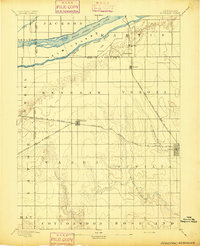
 1892 Grand Island1892 Print · USGSGrand Island and the surrounding Hall County prairies are captured in the late nineteenth century as a vital rail junction. Genealogists and historians can trace early track layouts of the Union Pacific R. R. and locate old settlements like Alda and Doniphan.
 - 1894 Map of Kenesaw
 1894 Kenesaw1894 Print · USGSRailroad development and the complex channels of the Platte River dominate the Nebraska landscape in the 1890s. Genealogists and historians can trace the early town plats of Kenesaw and Juniata or locate the historic Wood River Bridge.
 - 1895 Map of Grand Island
 1895 Grand Island1895 Print · USGSGrand Island emerged as a vital rail crossroads in central Nebraska during the late nineteenth century. Genealogists and historians can trace the early development of the city grid and surrounding settlements like Alda and Doniphan, or locate crossings such as the Island Bridge.
 - 1895 Map of Wood River
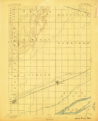 1895 Wood River1895 Print · USGSThe central Nebraska plains were undergoing a railroad-driven expansion in the 1890s as homesteads filled the townships. Researchers can trace early property lines and rail stops along the Union Pacific (Main Line) at Wood River and the braided channels of the North Channel Platte River.
 - 1896 Map of Wood River
 1896 Wood River1896 Print · USGSCentral Nebraska at the close of the nineteenth century is defined by its massive river islands and burgeoning rail towns. Local historians can trace early prairie commerce through the rail lines connecting Wood River, Shelton, and the distinctive Sugar Bowl terrain.4 unique versions available
 - 1898 Map of Grand Island
 1898 Grand Island1898 Print · USGSCentral Nebraska is captured in the late 1890s as a bustling rail and agricultural crossroads centered on the Platte River. Genealogists and historians can trace early settlements like Doniphan and Harvard or the grounds of the Insane Asylum outside Hastings.4 unique versions available
 - 1899 Map of Loup
 1899 Loup1899 Print · USGSCentral Nebraska at the end of the century was a land defined by its rivers and expanding rail lines. Genealogists can trace the early pioneer hubs of Dannebrog, Ashton, and Scotia along the Union Pacific RR.2 unique versions available
 - 1899 Map of St. Paul
 1899 St. Paul1899 Print · USGSCentral Nebraska's river valleys and rail hubs are preserved here during the expansion of the late 1890s. Researchers can trace the development of St. Paul and Central City alongside curious landmarks like Mumpumpey Hill and the Burlington and Missouri River R. R.4 unique versions available
End of results
Showing maps 1-8 of 8
Top cities of Hall County
- Grand Island historical maps
- Wood River historical maps
- Doniphan historical maps
- Cairo historical maps
- Alda historical maps
Frequently asked questions
- What are the different types of historical maps available for Hall County?
- What is the oldest map of Hall County?
- Where can I purchase historical maps of Hall County for my home or office?
- Where can I download high-res historical maps of Hall County?
- Are there historical topographic maps available for Hall County?
- Is there historical aerial imagery available for Hall County?
- Where are historical maps of Hall County sourced from?