
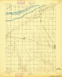
1892 Map of Grand Island
USGS Topo · Published 1892About this map
Grand Island serves as the central hub for a complex network of 1890s transportation routes and braided waterways. The settlement pattern is defined by the Union Pacific R. R. (Main Line) and the St. Joseph and Grand Island R. R., which converge at the town site. The landscape is dominated by the intricate channels of the Platte River, specifically the North Channel Platte River, Middle Channel Platte River, and South Channel Platte River. These waterways are crossed by notable early infrastructure like the Grand Island Bridge and the Hamilton Bridge. Beyond the main town, smaller settlements such as Alda, Doniphan, and Abbott are situated along the rail lines and creek beds, including Prairie Creek and Silver Creek. The map illustrates the late-19th-century transition from open prairie to a structured agricultural and railroad-driven economy.
Find a feature on this map
35 named features on this map. Tap any name to fly to it.
Don’t see what you’re looking for? This feature index may not catch every label — zoom into the map to look around manually.
Map Details
Editions of this 1892 Grand Island Map
This is the sole edition of this map. No revisions or reprints were ever made.
Other maps of this area
1894 · Kenesaw
USGS Topo · 1:62,500

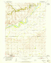
1895 · Grand Island
USGS Topo · 1:62,500
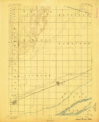
1895 · Wood River
USGS Topo · 1:62,500

1896 · Wood River
USGS Topo · 1:125,000

1898 · Grand Island
USGS Topo · 1:125,000

1899 · Loup
USGS Topo · 1:125,000

1899 · St. Paul
USGS Topo · 1:125,000
1953 · Dannebrog
USGS Topo · 1:24,000

1955 · Broken Bow
USGS Topo · 1:250,000

1955 · Grand Island
USGS Topo · 1:250,000