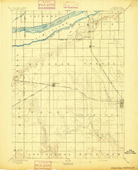
1894 Map of Kenesaw
USGS Topo · Published 1894About this map
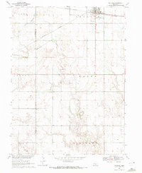
The braided channels of the Middle Channel Platte River and South Channel Platte River define the northern landscape of this 1892 survey, carving out the massive Elm Island. This area represents a critical junction of Nebraska's early rail infrastructure, where the Burlington and Missouri River Railroad (Main Line) intersects with the B. and M. R. R. (Kearney Br.) at Kenesaw. Further east, the town of Juniata sits at the crossing of the Missouri Pacific Railroad (Republican Valley Br.). To the south, the terrain transitions from the flat river valley into the dissected uplands drained by Cottonwood Creek and the West Branch Thirty-two Mile Creek. Distinctive landmarks like Sugar Bowl and Topeka Peak stand out against the agricultural grid, providing rare vertical relief in the central plains.
Find a feature on this map
32 named features on this map. Tap any name to fly to it.
Don’t see what you’re looking for? This feature index may not catch every label — zoom into the map to look around manually.
Map Details
Editions of this 1894 Kenesaw Map
This is the sole edition of this map. No revisions or reprints were ever made.
Historical Maps of Kenesaw Through Time
6 maps found