1900s (20th Century) Maps of Center, Nebraska
Explore 8 historic maps of Center from the 1900s (20th Century). These maps offer a rare glimpse into what life looked like during the 1900s — showing old roads, neighborhoods, homes, and landmarks that have changed or disappeared over time.
Whether you're researching your family's past, planning a metal detecting trip, or studying how Center's landscape evolved across the 1900s, these high-resolution maps are a powerful tool for exploring the history of this region.
- Focus on a specific era: All maps on this page are from the 1900s, giving you a focused view of this time period.
- See what’s changed: Compare century-old streets, trails, and buildings to today's modern landscape using overlays and satellite layers.
- Research with precision: Use these maps for genealogy, historical research, land use analysis, or educational projects.
- View, download, or print: Maps are fully viewable online in high resolution, and can be downloaded or printed for your own records.
Start exploring Center's history through authentic maps from the 1900s. This is your window into the past.
Center, NE maps
(8)- 1955 Map of Sioux City, 1959 Print
 1955 Sioux City1959 Print · USGSThe Missouri River valley in the mid-fifties is captured here during a time of major engineering and social transition. Genealogists and historians can trace the foundations of Gavins Point Dam, tribal boundaries on the Santee Sioux Indian Reservation, and local landmarks like the Norfolk State Hospital.4 unique versions available
 - 1958 Map of Sioux City
 1958 Sioux City1958 Print · USGSThe Missouri River valley in the late fifties was a bustling intersection of tribal lands, rail corridors, and river towns. Genealogists can trace family roots through specific rural sites like Daisy Valley School, St Johns Church and School, and Yankton State Hospital.
 - 1959 Map of Sioux City
 1959 Sioux City1959 Print · USGSThe tri-state region surrounding the Missouri River is captured here in the late fifties, showing the convergence of Nebraska, South Dakota, and Iowa. Researchers can trace rural lineages through numerous country schoolhouses like Cemetery School and the many numbered Washington School districts.
 - 1974 Map of Center West, 1978 Print
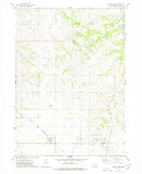 1974 Center West1978 Print · USGSKnox County in the mid-1970s shows a landscape defined by the Santee Indian Reservation Boundary and rural crossroads. Local researchers can trace the Chicago and North Western rail line or locate the Cedar Hill Cem near Bazile Mills.
 - 1974 Map of Center East, 1979 Print
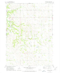 1974 Center East1979 Print · USGSKnox County, Nebraska, is seen here in the mid-seventies, documenting the rural landscape near Center. Researchers can locate the Morrillville Cem, trace the waters of Bazile Creek, and see the Santee Indian Reservation Boundary.
 - 1977 Map of Center East, 1979 Print
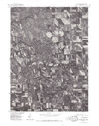 1977 Center East1979 Print · USGSKnox County farmland and the small settlement of Center are captured in this late-1970s orthophoto. Researchers can trace the winding course of Brazile Creek and the rise of center-pivot irrigation systems across the Nebraska prairie.
 - 1977 Map of Center West, 1979 Print
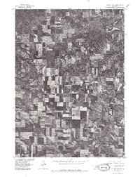 1977 Center West1979 Print · USGSNortheastern Nebraska's Knox County comes into sharp focus during the late seventies, showing a landscape defined by structured agriculture and creek-side settlements. Researchers can trace the layout of Winnetoon, Center, and the historic mill site at Bazile Mills.
 - 1985 Map of Yankton
 1985 Yankton1985 Print · USGSThe Missouri River borderlands of South Dakota and Nebraska come alive in this mid-eighties survey, centered on the newly created Lewis and Clark Lake. Researchers can trace the Santee Indian Reservation and locate historic river features like the St Helena Island Chute and Sand Island.2 unique versions available
End of results
Showing maps 1-8 of 8
Top cities near Center
- Creighton historical maps
- Bloomfield historical maps
- Verdigre historical maps
- Niobrara historical maps
- Sparta historical maps
- Winnetoon historical maps
See more
Frequently asked questions
- What are the different types of historical maps available for Center?
- What is the oldest map of Center?
- Where can I purchase historical maps of Center for my home or office?
- Where can I download high-res historical maps of Center?
- Are there historical topographic maps available for Center?
- Is there historical aerial imagery available for Center?
- Where are historical maps of Center sourced from?