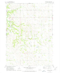
1974 Map of Center East
USGS Topo · Published 1979About this map
Center stands as the primary hub of activity in this northern Nebraska landscape, situated near the western edge of the survey area. The terrain is defined by the winding course of Bazile Creek and its tributary, Little Bazile Creek, which have carved distinctive drainage patterns through the upland plains. For genealogists and local historians, the presence of both the Morrillville Cem and Kemna Cem provides valuable points of reference for tracing family lineages and early burials in this part of Knox County. A significant administrative feature is the Santee Indian Reservation Boundary, which runs along the northern section of the map, marking the historic division of land use. Scattered Gravel Pits indicate localized rural industry, while the density of section lines and field boundaries reflects a late-twentieth-century agricultural economy fully established upon the land.
Find a feature on this map
9 named features on this map. Tap any name to fly to it.
Don’t see what you’re looking for? This feature index may not catch every label — zoom into the map to look around manually.
Map Details
Editions of this 1974 Center East Map
This is the sole edition of this map. No revisions or reprints were ever made.
Other maps of this area

1955 · Sioux City
USGS Topo · 1:250,000

1958 · Sioux City
USGS Topo · 1:250,000

1959 · Sioux City
USGS Topo · 1:250,000

1974 · Sparta
USGS Topo · 1:24,000

1974 · Lindy
USGS Topo · 1:24,000

1974 · Midland
USGS Topo · 1:24,000
1974 · Center West
USGS Topo · 1:24,000
1974 · Creighton
USGS Topo · 1:24,000

1974 · Bloomfield
USGS Topo · 1:24,000
1974 · Plainview NE
USGS Topo · 1:24,000