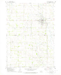
1974 Map of Creighton
USGS Topo · Published 1978About this map
Creighton serves as the focal point of this mid-1970s landscape, situated where the Chicago and North Western railroad line cuts through the northeastern Nebraska plains. The town's layout is well-documented, featuring landmarks such as Bruce Park, the Greenwood Cem, and a dedicated Sewage Disposal area. Beyond the residential grid, the Creighton Municipal Airport and its Beacon point toward the community's modern infrastructure, while a prominent Radio Tower stands on the western edge of town.
Find a feature on this map
18 named features on this map. Tap any name to fly to it.
Don’t see what you’re looking for? This feature index may not catch every label — zoom into the map to look around manually.
Map Details
Editions of this 1974 Creighton Map
This is the sole edition of this map. No revisions or reprints were ever made.
Other maps of this area

1954 · Verdigre
USGS Topo · 1:24,000

1955 · Sioux City
USGS Topo · 1:250,000

1955 · O'Neill
USGS Topo · 1:250,000

1958 · Sioux City
USGS Topo · 1:250,000

1959 · O'Neill
USGS Topo · 1:250,000

1959 · Sioux City
USGS Topo · 1:250,000

1963 · Orchard NE
USGS Topo · 1:24,000

1963 · Plainview
USGS Topo · 1:24,000

1963 · Brunswick
USGS Topo · 1:24,000

1963 · Royal
USGS Topo · 1:24,000