
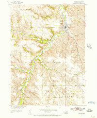
1954 Map of Verdigre
USGS Topo · Published 1956About this map
Verdigre stands as the primary hub of this Knox County landscape in the mid-1950s, situated at the junction of the Chicago and North Western railroad and the winding Verdigre Creek. The town is flanked by the St Wenceslaus Cem to the northwest and Riverside Cem to the east, reflecting the established community roots of the era. The surrounding agricultural sections are defined by a network of rural education sites, including School No 39, School No 24, Oak Valley Sch, and Pleasant Hill Sch. This survey, conducted as part of the Missouri River Basin development program, captures the intricate topography of the Bohemia and Sparta precincts. The map illustrates how local life was structured around the drainage of the North Branch and Middle Branch, where the rugged creek valleys intersect with the surveyed township lines.
Find a feature on this map
17 named features on this map. Tap any name to fly to it.
Don’t see what you’re looking for? This feature index may not catch every label — zoom into the map to look around manually.
Map Details
Editions of this 1954 Verdigre Map
2 editions found
Other maps of this area

1950 · Verdigre NE
USGS Topo · 1:24,000

1950 · Pishelville
USGS Topo · 1:24,000

1954 · Walnut
USGS Topo · 1:24,000

1955 · Sioux City
USGS Topo · 1:250,000

1955 · O'Neill
USGS Topo · 1:250,000

1958 · Sioux City
USGS Topo · 1:250,000

1959 · O'Neill
USGS Topo · 1:250,000

1959 · Sioux City
USGS Topo · 1:250,000

1963 · Orchard NE
USGS Topo · 1:24,000
1963 · Orchard NW
USGS Topo · 1:24,000