1970s Maps of Lindy, Nebraska
Explore 2 historic maps of Lindy from the 1970s. These maps offer a rare glimpse into what life looked like during the 1970s — showing old roads, neighborhoods, homes, and landmarks that have changed or disappeared over time.
Whether you're researching your family's past, planning a metal detecting trip, or studying how Lindy's landscape evolved across the 1970s, these high-resolution maps are a powerful tool for exploring the history of this region.
- Focus on a specific era: All maps on this page are from the 1970s, giving you a focused view of this time period.
- See what’s changed: Compare century-old streets, trails, and buildings to today's modern landscape using overlays and satellite layers.
- Research with precision: Use these maps for genealogy, historical research, land use analysis, or educational projects.
- View, download, or print: Maps are fully viewable online in high resolution, and can be downloaded or printed for your own records.
Start exploring Lindy's history through authentic maps from the 1970s. This is your window into the past.
Lindy, NE maps
(2)- 1974 Map of Lindy, 1978 Print
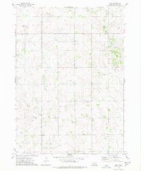 1974 Lindy1978 Print · USGSKnox County, Nebraska, is documented here in the mid-1970s, showing the agricultural lands surrounding the village of Lindy. Local historians can trace the SANTEE INDIAN RESERVATION BOUNDARY and geographic landmarks like Peoria and Hobo Creek.
 - 1977 Map of Lindy, 1979 Print
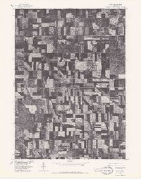 1977 Lindy1979 Print · USGSAgricultural patterns in Knox County are captured during the late seventies, showing the rural landscape around Lindy. Local historians and genealogists can trace property boundaries and identify specific farmstead locations as they appeared when this imagery was recorded.
End of results
Showing maps 1-2 of 2
Top cities near Lindy
- Springfield historical maps
- Bloomfield historical maps
- Tabor historical maps
- Santee historical maps
- Center historical maps
- Winnetoon historical maps
See more
Frequently asked questions
- What are the different types of historical maps available for Lindy?
- What is the oldest map of Lindy?
- Where can I purchase historical maps of Lindy for my home or office?
- Where can I download high-res historical maps of Lindy?
- Are there historical topographic maps available for Lindy?
- Is there historical aerial imagery available for Lindy?
- Where are historical maps of Lindy sourced from?