1960s Maps of Four Stones, Lancaster County
Explore 2 historic maps of Four Stones from the 1960s. These maps offer a rare glimpse into what life looked like during the 1960s — showing old roads, neighborhoods, homes, and landmarks that have changed or disappeared over time.
Whether you're researching your family's past, planning a metal detecting trip, or studying how Four Stones's landscape evolved across the 1960s, these high-resolution maps are a powerful tool for exploring the history of this region.
- Focus on a specific era: All maps on this page are from the 1960s, giving you a focused view of this time period.
- See what’s changed: Compare century-old streets, trails, and buildings to today's modern landscape using overlays and satellite layers.
- Research with precision: Use these maps for genealogy, historical research, land use analysis, or educational projects.
- View, download, or print: Maps are fully viewable online in high resolution, and can be downloaded or printed for your own records.
Start exploring Four Stones's history through authentic maps from the 1960s. This is your window into the past.
Four Stones, Lancaster County maps
(2)- 1964 Map of Cortland, 1965 Print
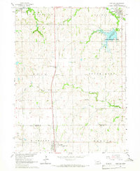 1964 Cortland1965 Print · USGSSoutheast Nebraska farmland is captured here in the mid-sixties, centered on the Union Pacific rail corridor between Hickman and Cortland. Genealogists and local historians can locate early landmarks like Stockfeldt Cem, Good Hope Sch, and the Stagecoach Lake recreation area.2 unique versions available
 - 1964 Map of Hallam, 1965 Print
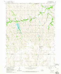 1964 Hallam1965 Print · USGSSoutheastern Nebraska is captured in the mid-sixties as utility and recreation developments reshaped the rural landscape. Researchers can locate several historic burial grounds like Kramer Community Cem and schoolhouses such as School No 11 along the Rock Island line.
End of results
Showing maps 1-2 of 2
Frequently asked questions
- What are the different types of historical maps available for Four Stones?
- What is the oldest map of Four Stones?
- Where can I purchase historical maps of Four Stones for my home or office?
- Where can I download high-res historical maps of Four Stones?
- Are there historical topographic maps available for Four Stones?
- Is there historical aerial imagery available for Four Stones?
- Where are historical maps of Four Stones sourced from?