1900s (20th Century) Maps of Loup County, Nebraska
Explore 29 historic maps of Loup County from the 1900s (20th Century). These maps offer a rare glimpse into what life looked like during the 1900s — showing old roads, neighborhoods, homes, and landmarks that have changed or disappeared over time.
Whether you're researching your family's past, planning a metal detecting trip, or studying how Loup County's landscape evolved across the 1900s, these high-resolution maps are a powerful tool for exploring the history of this region.
- Focus on a specific era: All maps on this page are from the 1900s, giving you a focused view of this time period.
- See what’s changed: Compare century-old streets, trails, and buildings to today's modern landscape using overlays and satellite layers.
- Research with precision: Use these maps for genealogy, historical research, land use analysis, or educational projects.
- View, download, or print: Maps are fully viewable online in high resolution, and can be downloaded or printed for your own records.
Start exploring Loup County's history through authentic maps from the 1900s. This is your window into the past.
Loup County, NE maps
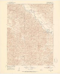
(29)- 1951 Map of Walworth, 1953 Print
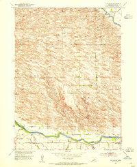
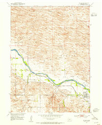
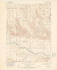 1951 Walworth1953 Print · USGSCuster County ranching country is documented here in the early fifties, centered on the Middle Loup River valley. Genealogists and historians can locate a high density of rural schoolhouses and cemeteries, such as Red Star Sch, Oxford Sch, and the Walworth Cem.3 unique versions available
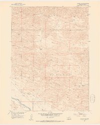
 - 1951 Map of Milburn, 1953 Print
 1951 Milburn1953 Print · USGSCuster County life in the early 1950s is centered here on the Middle Loup River and its rugged canyon breaks. Genealogists and local historians can trace rural schoolhouse locations like Columbia Table Sch and the community of Gates.3 unique versions available
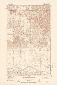
 - 1952 Map of Burwell, 1954 Print
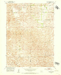
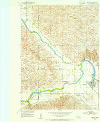 1952 Burwell1954 Print · USGSBurwell and the river valleys of Garfield County are shown in the early fifties as the region's agricultural and irrigation infrastructure matured. Genealogists and historians can trace local rural life through numerous sites like Gideon Sch, Banner Cem, and the Chicago Burlington and Quincy rail line.2 unique versions available
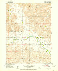
 - 1952 Map of Sargent East, 1954 Print
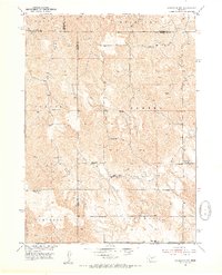
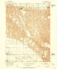 1952 Sargent East1954 Print · USGSCuster County agriculture and irrigation infrastructure are on full display in the early fifties, centered on the community of Sargent. Family historians can trace local schoolhouses like North Star Sch and Phillipsburg Sch or the rail path of the Chicago Burlington and Quincy.3 unique versions available
 - 1952 Map of Taylor NW, 1954 Print
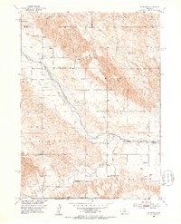
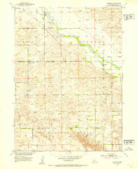
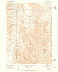
 1952 Taylor NW1954 Print · USGSThe Nebraska Sandhills in the early fifties reveal a landscape of isolated cattle operations and riparian corridors. Genealogists and historians can trace the Calamus River to find the Sebesta Sch and family landmarks like Upriver Ranch.4 unique versions available
 - 1952 Map of Almeria NE, 1954 Print
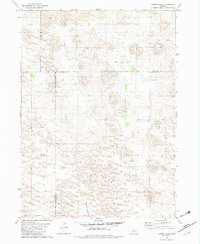
 1952 Almeria NE1954 Print · USGSLoup County ranch land in the early fifties shows a landscape of scattered windmills and early irrigation efforts. Genealogists can locate School No 32 (Abandoned) and trace the Abandoned Canal along the North Loup River.3 unique versions available
 - 1952 Map of Sargent West, 1954 Print
 1952 Sargent West1954 Print · USGSCuster County life in the early fifties was centered on the river valley and a network of rural school districts. Genealogists can trace family footprints through sites like West Union Cem, Zion Hill Sch, and the township of Madison Square.4 unique versions available
 - 1952 Map of Almeria NW, 1954 Print
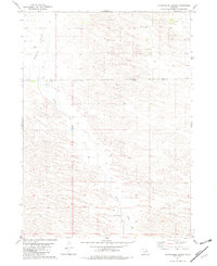
 1952 Almeria NW1954 Print · USGSThe Nebraska Sandhills come alive in the early 1950s as ranchers and farmers managed the waters of the North Loup River. Trace family footprints through local landmarks like Pleasant Valley Sch, Peterson Ranch, and the Church of God.4 unique versions available
 - 1952 Map of Taylor SE, 1954 Print
 1952 Taylor SE1954 Print · USGSLoup County ranching country is meticulously detailed in the early fifties, showing the vital waterways and school districts of the era. Genealogists can locate family schoolhouses such as Lone Star Sch, Round Hill Sch, and Kent Sch.2 unique versions available
 - 1952 Map of Almeria SW, 1954 Print
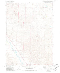
 1952 Almeria SW1954 Print · USGSThe Nebraska Sandhills come into sharp focus in the early fifties, showing a landscape of dunes and isolated ranching districts. Genealogists and historians can trace the rural layout of Brewster and Sawyer or locate the Dry Valley Sch.
 - 1952 Map of Comstock NW, 1954 Print
 1952 Comstock NW1954 Print · USGSThe high plains of central Nebraska were a patchwork of rural school districts and immigrant parish life in the early fifties. Genealogists can trace local roots through landmarks like the Bohemian Brotherhood Cemetery, Jungmann Hall, and the Boleszyn Church.2 unique versions available
 - 1952 Map of Almeria, 1954 Print
 1952 Almeria1954 Print · USGSLoup County’s river-carved landscape comes into focus here in the early fifties, documenting a network of rural schools and townships. Genealogists and historians can locate community cornerstones like Knobby Ridge Sch, Almeria Cem, and the Town Hall in Madison Square.3 unique versions available
 - 1952 Map of Taylor, 1954 Print
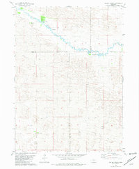
 1952 Taylor1954 Print · USGSThe Loup River valley comes to life in the early 1950s, showing the intersection of ranching life and water management. Genealogists and local historians can locate family landmarks like Worm Ranch and Britton Ranch alongside the Sunnyside Sch.2 unique versions available
 - 1952 Map of Burwell NW, 1954 Print
 1952 Burwell NW1954 Print · USGSGarfield and Loup Counties are shown at the height of the mid-century ranching era, defined by the isolated homesteads and dunes of the Nebraska Sandhills. Researchers can locate the Garska Ranch, trace the drainage of Dry Creek, and find School No 32 (Abandoned).3 unique versions available
 - 1952 Map of Taylor NE, 1954 Print
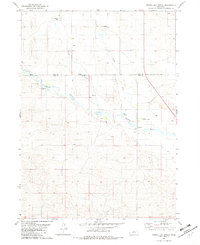
 1952 Taylor NE1954 Print · USGSThe Calamus River valley in the early 1950s reveals a specialized ranching landscape defined by family operations and remote outposts. Genealogists and historians can trace local landmarks like Valley View Sch, Conner Ranch, and the Landing Field near the river.2 unique versions available
 - 1955 Map of Broken Bow
 1955 Broken Bow1955 Print · USGSCentral Nebraska in the mid-fifties is defined by the sweeping Sand Hills and the vital river valleys that supported its ranching and rail towns. Researchers can trace the rail corridors of the Union Pacific RR and locate settlements like Dannebrog, Broken Bow, and Brewster.5 unique versions available
 - 1955 Map of O'Neill, 1974 Print
 1955 O'Neill1974 Print · USGSNorth-central Nebraska in the 1950s reveals a vast cattle-ranching landscape transitioning from the Missouri River breaks to the iconic Sand Hills. Researchers can trace the path of the Chicago and North Western rail line and locate rural landmarks like the Dustin Post Office and St Johns Lake Ch.2 unique versions available
 - 1956 Map of Broken Bow
 1956 Broken Bow1956 Print · USGSCentral Nebraska during the mid-fifties reveals a region defined by its river-valley railroads and the rolling Sand Hills. Genealogists and local historians can trace the paths of the Chicago Burlington and Quincy through towns like Broken Bow, Merna, and Anselmo.
 - 1959 Map of O'Neill
 1959 O'Neill1959 Print · USGSNorth-central Nebraska in the late fifties is defined by the vast Sand Hills and the vital Chicago and North Western rail line. Genealogists and researchers can trace family roots through settlements like Atkinson, Bassett, and Stuart or follow the waters of the Niobrara River.2 unique versions available
 - 1969 Map of O'Neill
 1969 O'Neill1969 Print · USGSCentral Nebraska in the mid-fifties is defined here by the expansive Sand Hills and the winding Niobrara River. Trace the Chicago and North Western rail line through cattle towns like O'Neill and Ainsworth.
 - 1981 Map of Boiling Spring
 1981 Boiling Spring1981 Print · USGSFour Nebraska counties meet along the Calamus River in the early 1980s, revealing a landscape of remote cattle operations. Genealogists and historians can trace the footprints of family holdings like Easy Hour Ranch, Spencer Ranch, and the waters of Boiling Spring.
 - 1981 Map of Shovel Dot Ranch, 1982 Print
 1981 Shovel Dot Ranch1982 Print · USGSThe cattle country of Rock and Loup Counties comes into focus in the early eighties as ranching operations sit alongside the meandering Calamus River. Local history and land use are visible through named outposts like Shovel Dot Ranch, the Weber Ranch, and the Fox Bridge crossing.
 - 1981 Map of Carson Lake, 1982 Print
 1981 Carson Lake1982 Print · USGSGarfield County ranching lands are captured in the early 1980s, documenting a remote landscape defined by wide meadows and creek beds. Genealogists and local historians can trace legacy holdings like Taylor Ranch and Noyes Ranch near the shores of Carson Lake.
 - 1981 Map of Stonehouse Ranch, 1982 Print
 1981 Stonehouse Ranch1982 Print · USGSThe Nebraska Sandhills come into focus in the early eighties at the intersection of Rock and Loup Counties. Family researchers and historians can locate the Stout Ranch, Sitz Ranch, and the rural Pleasant Hill Sch among the dunes.
 - 1981 Map of Stonehouse Ranch SW, 1982 Print
 1981 Stonehouse Ranch SW1982 Print · USGSLoup and Rock counties are captured here in the early 1980s, showcasing the remote ranching culture of the Nebraska Sandhills. Researchers can trace land use through labeled cattle operations like C 7 Ranch and the winding course of the Calamus River.
Showing maps 1-25 of 29
Top cities of Loup County
Frequently asked questions
- What are the different types of historical maps available for Loup County?
- What is the oldest map of Loup County?
- Where can I purchase historical maps of Loup County for my home or office?
- Where can I download high-res historical maps of Loup County?
- Are there historical topographic maps available for Loup County?
- Is there historical aerial imagery available for Loup County?
- Where are historical maps of Loup County sourced from?