1960s Maps of Nemaha County, Nebraska
Explore 13 historic maps of Nemaha County from the 1960s. These maps offer a rare glimpse into what life looked like during the 1960s — showing old roads, neighborhoods, homes, and landmarks that have changed or disappeared over time.
Whether you're researching your family's past, planning a metal detecting trip, or studying how Nemaha County's landscape evolved across the 1960s, these high-resolution maps are a powerful tool for exploring the history of this region.
- Focus on a specific era: All maps on this page are from the 1960s, giving you a focused view of this time period.
- See what’s changed: Compare century-old streets, trails, and buildings to today's modern landscape using overlays and satellite layers.
- Research with precision: Use these maps for genealogy, historical research, land use analysis, or educational projects.
- View, download, or print: Maps are fully viewable online in high resolution, and can be downloaded or printed for your own records.
Start exploring Nemaha County's history through authentic maps from the 1960s. This is your window into the past.
Nemaha County, NE maps
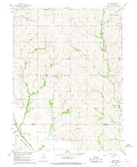
(13)- 1965 Map of Tecumseh SE, 1966 Print
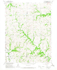 1965 Tecumseh SE1966 Print · USGSThe town of Elk Creek is shown in the mid-1960s at the junction of the Nemaha River and the Chicago Burlington and Quincy railroad. Trace family history through numerous rural landmarks like Stutheit Cem and St James Ch.
 - 1966 Map of Tecumseh NE, 1967 Print
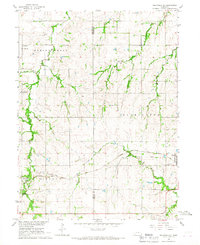 1966 Tecumseh NE1967 Print · USGSThe rural intersection of Johnson and Nemaha counties in the mid-1960s highlights a landscape of family farms and active rail lines. Researchers can find precise locations for Spring Creek Sch No 21, Zion Ch, and the St Matthews Cem.
 - 1966 Map of Howe SW, 1967 Print
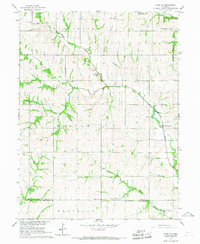 1966 Howe SW1967 Print · USGSSoutheast Nebraska in the 1960s was a landscape of quiet township lines and creek-side communities. Genealogists can trace family footprints through sites like Pleasant View Cem, St Johns Ch, and the Bratton Union Sch.
 - 1966 Map of Julian, 1968 Print
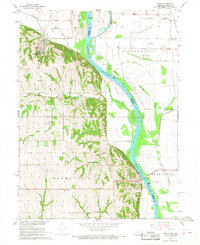
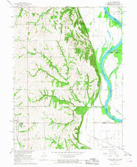 1966 Julian1968 Print · USGSThe Missouri River bottoms and Nebraska uplands are captured here in the mid-1960s as the river defines the borders of three states. Researchers can trace rural life through the locations of St Bernards Ch, Minersville, and several country schools like Hazel Dell Sch.2 unique versions available
 - 1966 Map of Nemaha, 1968 Print
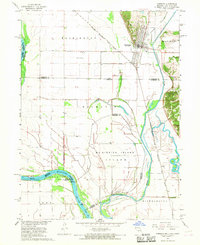
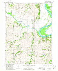 1966 Nemaha1968 Print · USGSSoutheast Nebraska and the Missouri River border are captured in the mid-sixties, showing the river’s winding course near Nemaha. Researchers can trace the Chicago Burlington and Quincy rail line, find the Maple Grove Sch, and locate the Pennwell Cem in the hills.2 unique versions available
 - 1966 Map of Talmage, 1968 Print
 1966 Talmage1968 Print · USGSThe river-and-rail landscape of southeast Nebraska is captured here in the mid-1960s. Genealogists can trace family footprints across rural sites like Walnut Hill Sch, Livingston Cem, and the village of Talmage.
 - 1966 Map of Langdon, 1968 Print
 1966 Langdon1968 Print · USGSThe Missouri-Nebraska borderlands are captured here in the mid-sixties, where the Missouri River meets the Barada Hills. Genealogists and researchers can trace the rail lines of the Chicago Burlington and Quincy or locate rural sites like St Peters Ch and Hunter Cem.3 unique versions available
 - 1966 Map of Brock, 1968 Print
 1966 Brock1968 Print · USGSNemaha County farm country comes into focus in the mid-1960s, showing the intersection of river life and rail transit. Trace family roots at Old Glenrock Cem or locate rural landmarks like Coryell Chapel and St Pauls Ch.
 - 1966 Map of Peru, 1968 Print
 1966 Peru1968 Print · USGSThe Missouri River floodplain near the Nebraska-Missouri border comes to life in the mid-sixties, centered on the bluff-side town of Peru. Genealogists and historians can locate rural landmarks like Mt Vernon Cem, Locust Grove Sch, and the Peru State College campus.2 unique versions available
 - 1966 Map of Hamburg, 1968 Print
 1966 Hamburg1968 Print · USGSSouthwest Fremont County is captured here in the late sixties at the three-state junction of Iowa, Missouri, and Nebraska. Genealogists and historians can trace the town of Hamburg, the Hamburg Cem, and the path of the Chicago Burlington and Quincy railroad.2 unique versions available
 - 1966 Map of Auburn, 1968 Print
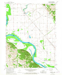
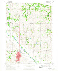 1966 Auburn1968 Print · USGSAuburn and the surrounding Nemaha County landscape are captured here in the mid-1960s, showing a transition from traditional rail-side commerce to modern infrastructure. Genealogists can locate family landmarks like Sheridan Cem, Bethel Ch, and Highland Sch.
 - 1966 Map of Howe, 1968 Print
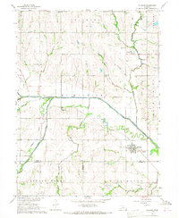
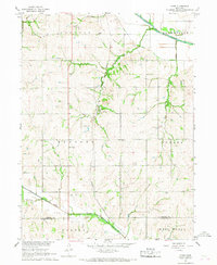 1966 Howe1968 Print · USGSSoutheast Nebraska in the mid-sixties reveals a countryside shaped by rail lines and river valleys. Genealogists and local historians can locate early landmarks like Cockran Sch, the Missouri Pacific Railroad, and Bedford Cem.
 - 1966 Map of Paul, 1968 Print
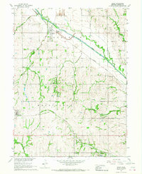
 1966 Paul1968 Print · USGSSoutheast Nebraska was a landscape of established farmsteads and rail-side villages in the mid-sixties. Researchers can trace the legacy of early settlements through sites like Paul, Bloomingdale Cem, and the tracks of the Missouri Pacific.
End of results
Showing maps 1-13 of 13
Top cities of Nemaha County
- Auburn historical maps
- Peru historical maps
- Johnson historical maps
- Nemaha historical maps
- Brock historical maps
- Brownville historical maps
See more
Frequently asked questions
- What are the different types of historical maps available for Nemaha County?
- What is the oldest map of Nemaha County?
- Where can I purchase historical maps of Nemaha County for my home or office?
- Where can I download high-res historical maps of Nemaha County?
- Are there historical topographic maps available for Nemaha County?
- Is there historical aerial imagery available for Nemaha County?
- Where are historical maps of Nemaha County sourced from?