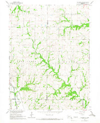
1965 Map of Tecumseh SE
USGS Topo · Published 1966About this map
Elk Creek serves as the primary hub in this mid-1960s landscape, situated near the confluence of the Big North Fork and the Nemaha River. The area is defined by a dense network of rural infrastructure, where the Chicago Burlington and Quincy railroad tracks cut across the southern township lines. The mapping of field lines and property boundaries across Todd Creek and Benton reveals a highly organized agricultural grid, punctuated by long-established local institutions such as St Martin Luther Ch and St James Ch. Numerous family and community burial grounds, including the Stutheit Cem and Mt Zion Cem, are scattered throughout the hills, providing essential markers for genealogists and local historians tracing the settlement patterns of Johnson, Nemaha, and Pawnee counties. The drainage of Robinson Creek and Spring Creek into the river valley highlights the complex topography that dictated early homestead placement.
Find a feature on this map
28 named features on this map. Tap any name to fly to it.
Don’t see what you’re looking for? This feature index may not catch every label — zoom into the map to look around manually.
Map Details
Editions of this 1965 Tecumseh SE Map
This is the sole edition of this map. No revisions or reprints were ever made.
Other maps of this area

1915 · Howe
USGS Topo · 1:62,500

1916 · Humboldt
USGS Topo · 1:62,500

1955 · Nebraska City
USGS Topo · 1:250,000

1955 · Lincoln
USGS Topo · 1:250,000

1957 · Nebraska City
USGS Topo · 1:250,000

1957 · Lincoln
USGS Topo · 1:250,000

1958 · Lincoln
USGS Topo · 1:250,000

1958 · Nebraska City
USGS Topo · 1:250,000

1965 · Table Rock
USGS Topo · 1:24,000

1965 · Tecumseh
USGS Topo · 1:24,000