1960s Maps of Nuckolls County, Nebraska
Explore 8 historic maps of Nuckolls County from the 1960s. These maps offer a rare glimpse into what life looked like during the 1960s — showing old roads, neighborhoods, homes, and landmarks that have changed or disappeared over time.
Whether you're researching your family's past, planning a metal detecting trip, or studying how Nuckolls County's landscape evolved across the 1960s, these high-resolution maps are a powerful tool for exploring the history of this region.
- Focus on a specific era: All maps on this page are from the 1960s, giving you a focused view of this time period.
- See what’s changed: Compare century-old streets, trails, and buildings to today's modern landscape using overlays and satellite layers.
- Research with precision: Use these maps for genealogy, historical research, land use analysis, or educational projects.
- View, download, or print: Maps are fully viewable online in high resolution, and can be downloaded or printed for your own records.
Start exploring Nuckolls County's history through authentic maps from the 1960s. This is your window into the past.
Nuckolls County, NE maps
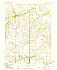
(8)- 1960 Map of Byron, 1961 Print
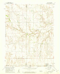 1960 Byron1961 Print · USGSThe Nebraska-Kansas borderlands in the early sixties remain a patchwork of small-town school districts and prairie parishes. Trace family history through landmarks like Bethany Ch, School No 91, and Zion Cem along the winding Spring Creek.
 - 1960 Map of Edgar, 1961 Print
 1960 Edgar1961 Print · USGSClay and Nuckolls Counties come to life at the turn of the 1960s as a hub of Nebraska rail commerce. Genealogists and historians can trace the foundations of local life through rural landmarks like Pioneer Sch, the town of Edgar, and the winding Little Blue River.
 - 1960 Map of Davenport, 1961 Print
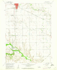
 1960 Davenport1961 Print · USGSDavenport was a bustling rail crossroads in the early sixties where two major lines intersected amidst the creek valleys of southern Nebraska. Researchers can trace the town's original footprint, find the local Cem, and follow the Union Pacific and Chicago and North Western tracks.
 - 1960 Map of Fairfield SE, 1961 Print
 1960 Fairfield SE1961 Print · USGSThe rural landscapes of Clay and Nuckolls Counties come into focus here during the early sixties. Genealogists and local historians can trace the foundations of these prairie communities through sites like Pleasant Hill Cem, Oxbow Sch, and the Chicago Burlington and Quincy rail line.
 - 1960 Map of Oak, 1961 Print
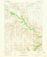
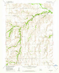
 1960 Oak1961 Print · USGSNuckolls County during the early sixties shows a landscape defined by the Little Blue River and the Chicago and North Western rail line. Researchers can locate the Oak Mill, trace the Old Railroad Grade, and find family sites at Nora Cem.
 - 1960 Map of Ruskin, 1962 Print
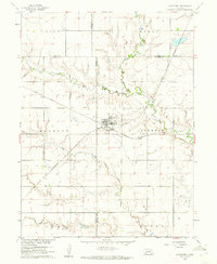
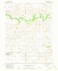 1960 Ruskin1962 Print · USGSAgricultural life in South Central Nebraska is captured here at the start of the 1960s, centered on the village of Ruskin. Genealogists and local historians can locate specific sites like St Marks Cem, Bethlehem Sch, and the Chicago Rock Island and Pacific rail corridor.
 - 1960 Map of Deweese, 1962 Print
 1960 Deweese1962 Print · USGSAgricultural life along the Little Blue River is captured in the early 1960s as Deweese thrived on the Chicago Burlington and Quincy line. Genealogists can locate family landmarks like Sacred Heart Cem and Roth Sch.
 - 1969 Map of Lawrence, 1971 Print
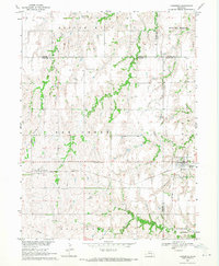 1969 Lawrence1971 Print · USGSLawrence and its neighboring rural communities are captured here in the late sixties at the junction of the Nebraska grain railways. Genealogists and local historians can trace family locations near St Stephens, Rosemont, and Oak Creek Cem.
End of results
Showing maps 1-8 of 8
Top cities of Nuckolls County
- Superior historical maps
- Nelson historical maps
- Lawrence historical maps
- Hardy historical maps
- Ruskin historical maps
- Oak historical maps
See more
Frequently asked questions
- What are the different types of historical maps available for Nuckolls County?
- What is the oldest map of Nuckolls County?
- Where can I purchase historical maps of Nuckolls County for my home or office?
- Where can I download high-res historical maps of Nuckolls County?
- Are there historical topographic maps available for Nuckolls County?
- Is there historical aerial imagery available for Nuckolls County?
- Where are historical maps of Nuckolls County sourced from?